Measuring and managing soil water who is doing what in WA
Author: Yvette Oliver and Christian Roth - CSIRO and the Soil Water Champions Panel | Date: 13 May 2014
Measuring and managing soil water – who is doing what in WA.
Yvette Oliver and Christian Roth, CSIRO and the “Soil Water Champions” panel;
Dennis van Gool, Rob Grima, David Hall, Jeremy Lemon and Caroline Peek – DAFWA, Julianne Hill and Cameron Weeks - Regional Cropping Solutions Network Co-ordinators, Rebecca Wallis – Grower Group Alliance, Frank D’Emdem – Precision Agronomics Australia, Geoff Fosbery - Consult Ag , David Stead – Anasazi Agronomy, Craig Topham - Agrarian
Key messages
- Soil water is now monitored throughout WA, using soil water probes and using tools such as Yield Prophet. The “Soil Water Champions” panel and the GRDC funded “Measuring and managing soil water” project will collate this resource across the industry to improve co-ordination and dissemination of soil water information.
- The project will improve farmers’ and consultants’ understanding of how to use of soil water information in farm decision making and the project will determine whether the current tools meet the industry’s needs. Training will be provided to help participants increase their base soil and soil water knowledge. Training will also be provided on how to use the soil water tools available (i.e. MyCrop, Yield Prophet and soil water probes) usinglocally relevant examples.
- The project will characterise 105 soils in WA over three years, targeting regional gaps and the heavier soils, and gravel and duplex soils often considered difficult to characterise. This will be facilitated by using linkages with existing trials (i.e. Focus Paddocks) and grower group efforts.
- The quality of soil water characterisation data in APSoil (existing and future) will be improved with additional soil sampling and using improved protocols for measuring problem soils and guided by a table of expected values based on soil texture.
- The ability to select a soil for modelling will be improved in APSoil/Yield Prophet through better linkages between APSoil and-MySoil, supported by training in selection and understanding of soil characterisations. This will include surrogates to estimate soil water and generic soils which may be more appropriate for some circumstances.
Aims
To provide information from a scoping study on “Measuring and managing soil water in WA” and the recommendations which inform the directions of the current 3 year GRDC funded project. The scoping study focussed on determining a) What soil water information and tools were available, b) Who was doing what in soil water measuring and managing trials, c) What were issues with soil water measuring and managing and d) What were the training requirements.
Method
The scoping study report was based on 1) a desk top study, 2) key informant interviews, comprising information from the “Soil water champions” meeting and email discussions, 3) an email survey to grower groups, DAFWA, CSIRO and consultants, and 4) regional workshops held in Geraldton, Narrogin, Kellerberrin and Esperance.
Results
What do we mean by soil water and what tools can we use?
Soil water seems to be a buzz at the moment! However, there is some confusion about what soil water is, what it means and how this information can be used. Therefore we provide some background to each of these concepts
Soil Characterisation
The term soil water characterisation means the measurement of the plant available water capacity (PAWC), soil chemistry (i.e. pH, Al, EC, boron, sodicity, cations), soil physical properties (particle size and penetration resistance) and soil classification (WA soil group and Australian soil classification). The PAWC (in mm) is the total amount of soil water available to the crops that a soil can store. It is the difference between how much water the soil can hold against gravity (the drained upper limit, DUL) and how much the crops can extract (crop lower limit, CLL). The PAWC integrates the ability of the crop to extract water from the soil with depth as affected by the rooting pattern of the crop. The rooting pattern is in turn affected by soil properties and subsoil constraints. The soil water characterisations are then entered into APSoil/SoilMapp and are available for growers to view or use in Yield Prophet.
The PAWC is then used for determining the yield potential for a past season in MyCrop and CliMate (web and iPad app), or the specific soil characterisation used in Yield Prophet, which determines the range of yield potentials base on the current season conditions and management in Yield Prophet.
Soil water at a point in time
The soil water is measured at a point in time at range of soil depths using soil coring and neutron probes or measured continuously (e.g. at 15 minute intervals) using soil water probes. The plant available water is how much of this soil water is available to the crops, calculated from subtracting the crop lower limit water content from the soil water content measurement at a point in time.
Soil water measurements are commonly taken near the start of the cropping season (March-April) and indicate how much of the summer rainfall is in the soil profile. This could have been affected by summer weeds, stubble management and summer rainfall pattern. How much plant available water is stored at the start of the season may affect decisions of time of sowing, dry sowing or alter your summer management. This can also be estimated from tools such as “HowWet” and Yield Prophet. In-season soil water measurements can be used for decisions on nutrient management, spraying or grazing. Whereas end of season measurements, which are commonly the crop lower limit, can indicate water left in the profile due to subsoil constraints.
What soil information is available
The expected soil types and constraints in your region can be determined from DAFWA soil maps and reports and the MySoil website. Soil characterisation data is available in APSoil and SoilMapp (iPad app) and is mostly used by Yield Prophet and APSIM users. There are 163 cropping soils in APSoil from WA (see Fig. 1).
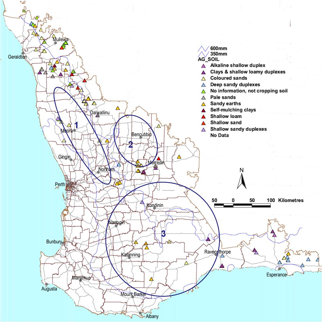
Figure 1 APSoil characterisation sites grouped by MySoil type with circle indicating regional gaps.
Regional gaps in the north include: West of the Great Northern Highway (No. 1 in Fig 1) and east of Dalwallinu down to Merredin (No. 2 in Fig 1) and smaller areas north of Geraldton, the Northampton block. The southern region has only a few scattered soil sites with gaps in the region south of the Great Eastern Highway (No 3. in Fig 1). Even though there are 12 soils in the Esperance region, the local consultants did not feel they cover the area sufficiently.
The gaps in soil types in APSoil were determined from the percentage area of the MySoil group and the number of APSoil sites in that group. While some MySoil groups are overrepresented in APSoil (e.g. coloured sands, sandy earths) there are also a large number groups that are only partially represented such as the alkaline shallow duplexes, calcareous loamy earths, deep loamy duplexes and earths and gravels.
Who’s doing what, and what issues do they have
The agriculture community (DAFWA, CSIRO, grower groups and farmers) is undertaking a range of activities which measure and monitor soil water including: Yield prophet, soil water probes, focus paddocks and agronomic trials investigating fallow management, soil acidity, crop variety choice, yield potential, dry seeding, cover crops, stubble management, time of sowing, water-use-efficiency and plant available water mapping. However there is little co-ordination of effort or method for disseminating the information for those measuring this data.
Yield Prophet
There were 234 Yield Prophet sites spread across WA (Fig 2). Of these sites, 135 are related to the DAFWA research trials project. Management of the DAFWA sites varies and is spread across DAFWA staff (28), consultants (93) and grower groups (14, but often with DAFWA assistance). Only five agronomy consulting companies were using Yield Prophet with their clients as a fee service, but they accounted for 85 sites in 2013. There were three grower groups using Yield Prophet across 14 sites, but they often drew on the assistance of an agronomist or DAFWA staff.
The main issues for use of Yield Prophet that the workshop discussions revealed were:
- Difficulty picking a soil from the database (APSoil) – gaps in soils that match the users’ soil, lack of knowledge about soils (i.e. soil naming), what the soil PAWC means, difficulty with system itself (names etc).
- Characterisations – not many are doing a characterisation as they are considered time consuming and costly, and there is some difficulty to do characterisations correctly on duplex soils and gravels.
- Adjusting soils for subsoil constraints – difficulties and help required on how to do this
- Uncertainty on level or accuracy required – rules of thumb, variability across sites.
- More effective use of Yield Prophet requires a better understanding of the outputs from Yield Prophet and how to link this to management decisions.
- A better understanding of the limitations of models is required – not using beyond its capability (i.e. not using for non-wetting or water-logging sites)
- Improved communication for soil water and Yield Prophet to “Get the message out there”
Soil water probes
Fifty seven soil water probes have been installed over the last few years, with more planned this year. The probes are located in the Esperance region, south coast and Mullewa areas (Fig 3). They were installed as part of GRDC funded projects, by grower groups as well as privately installed. Most installations use one or two probes on a particular soil type in a given paddock, with exception of 9 probes installed in one paddock in Dalwallinu, which are part of a stubble management trial managed by the Liebe group.
The soil water probes measure the soil water at 15 minute intervals and at 10-20 cm increments down the profile. Probes are generally installed at 20 cm depth, to be away from sowing machinery, with some sites also including a removable surface probe for the 0-10 cm measurements. Soil water probes are ideal for continuous soil water measurement and are often linked to a weather station at that site, which also provides valuable information. The probes may, over time, be used for the soil water characterisation at that site. Researchers use the soil water probes on trials to see the effect of management or amelioration on the crop’s ability to extract water from the soil at depth and over time.
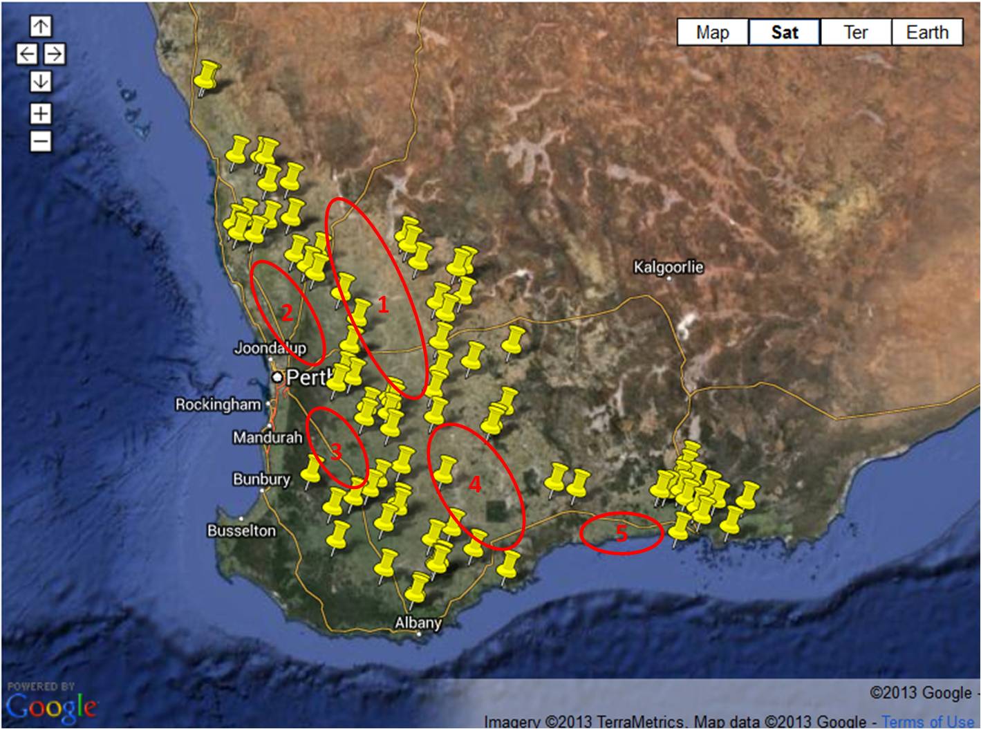
Fig 2. Location of the Yield Prophet sites in 2013.Google map - taken from DAFWA website.
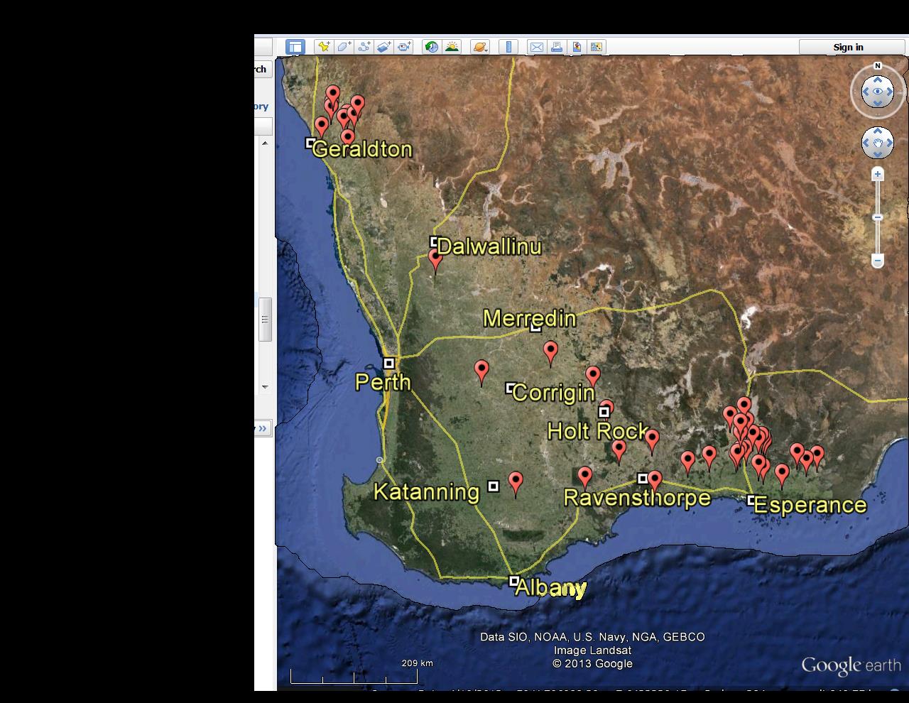
Fig 3. Location of soil water probes in WA (as of Dec 2014). Google map with data provided by Precision Agronomic Australia and Farmlink Rural
However soil water probes have issues which should be considered such as:
- They often require calibration, which requires numerous sampling holes to be cored
- Soil probes only measure <10 cm from probe and may be subjected to errors associated with lack of crop near probe or roots wrapping around the probe
- Results are specific to the soil, crop management and previous cropping history at that site
- The way the information from the probes is displayed can be confusing and requires time and training to understand. For an example see http://www.sepwa.org.au/index.php/2011-11-15-05-40-21/soil-moisture-probes.
Conclusion
As a result of the scoping study, we now have a panel of “Soil Water Champions” who will provide linkage between CSIRO, DAFWA, grower groups and consultants. This project will act as a link to the Focus Paddock initiative, GRDC subsoil constraint projects, as well as the Water Use Efficiency and others projects to assist with training, characterisation and monitoring of soil water.
Regional and soil type gaps in characterisations have been identified and will be overcome with 105 additional soil characterisations sites planned over the next 3 years. Common issues relating to difficulties in selecting a soil form the APSoil database will be overcome with more characterisations, improved guidelines to pick a soil by linking to MySoil and improved protocols for measuring PAWC. Training and other communication methods will be used to increase awareness of soil types, soil PAWC, how characterise soils, selecting appropriate soil data from existing databases and using soil water tools.
Key words
Plant available water capacity (PAWC), soil water, soil water probes, Yield Prophet, yield potential
Acknowledgments
Thanks for the invaluable input from the farmers and staff from the agronomy consultancies, grower groups, DAFWA and CSIRO who responded to emails and attended workshops.
GRDC Project No.: CSP00170
Paper reviewed by: Roger Lawes
Was this page helpful?
YOUR FEEDBACK