UAVs in broadacre agriculture - is there profit in pixels?
Author: Ben Boughton (Nuffield scholar, Grower Gilroy Farms Moree and Satamap) | Date: 20 Mar 2015
Take home messages
- Despite US lagging behind in regulations to operate unmanned aerial vehicles (UAVs), there are lots of innovative companies attempting to make money in the space. E.g. Agribotix has commercialised the whole workflow from data to actionable information.
- UAVs, like satellite imagery are a remote sensing platform. The operational function of the UAV needs to be understood, but most of the complexity lies in the sensor and data processing. Cost benefit of UAV versus satellite data should be considered.
- Several challenges exist that need to be considered before relying on UAV technology. Some include repeatability and data calibration, spatial accuracy, handling data processes and integrating with existing precision agriculture systems.
Introduction
- Unmanned aerial vehicles (UAVs) have been suggested as an ideal way to collect high quality spatial, spectral and temporal data that can assist in productivity gains. A small fixed wing design is suitable for the grains industry.
- Some potential use cases include crop scouting, site specific weed control and high accuracy topographic mapping.
Nuffield travels – UAVs in USA and Canada
- Huge amount of development from existing companies such as Trimble, some exciting well-funded companies such as Precision Hawk and 3D Robotics, early starters that have done well such as AgEagle, down to smaller start-up companies like Agribotix and Swift Radio Planes which are just getting off the ground. Despite Australia having a better regulated airspace for UAVs than the US, we do not seem to have the start-up culture driving local development.
- There are conferences devoted to UAVs in agriculture. The audience are extremely diverse – from curious farmers, agronomists, all the way to sensor and software companies and interestingly a large presence from insurance companies. Conferences I attended whilst in the US included:
- Precision Ag Aerial Show.
- Delta Ag Tech Symposium.
- US farmers have been experimenting with quad-copter with GoPro and some more adventurous have purchased AgEagle and been mapping larger areas despite current laws. Some actually buy their own systems at about $20,000 each. Quad-copters are usually just used to capture video (e.g. centre pivot inspection or corn crop 'scouting') – no real spatial information. Agribotix map and process large areas of farming country – look them up for ideas of pricing models, case studies and a heap of great information (agribotix.com). Canada has some established companies delivering UAV mapping services.
- Several universities have certificates of operation to operate UAVs and have been testing extensively with the robust fixed wing systems in anticipation of relaxed FAA laws. This means in the near future when the FAA changes the rules, the larger companies could catch up/surpass those already operating in this space very quickly.
- Demonstrations of some early versions of vectorization (i.e. points, lines and polygons) in their server solutions using imagery collected via UAVs with the main example variable rate application map of fertilizer in crop based on NDVI. This is not new technology – it has been done with satellite imagery for years. SST has updated their software to allow UAV imagery to be imported to produce zone maps.
UAVs at Gilroy Farms
- 2013/2014 saw extensive development of a homemade UAV based on a Finwing Penguin fixed wing platform. A working system was able to be built for less than $2,000 but at that point information was limited and time investment was huge.
- Hindsight revealed that less time should have been spent on the UAV platform itself and more on the sensor and processing equipment. Several complete, cheap UAV packages are now available (e.g. 3D robotics website and Event 38 website).
- I was able to collect data at various crop stages. Using just a Canon handheld camera, imagery was detailed enough to identify old tramlines, individual weeds, livestock tracks, planter malfunctions and wheat population differences.
- In September we had a Trimble UX5 UAV map 100ha of wheat. I took the raw imagery and processed it on my own computer. I was able to classify out ryegrass from wheat. This process is not for the faint hearted (i.e. computer illiterate).
- I learnt that while the commercial systems generally ‘just work’ they still require an operational understanding of how the system works. E.g. the Trimble system has no full manual control and the autopilot cannot ‘see’ trees or fences when coming into land.
- Challenges include:
- Spatial accuracy: seeing a weed in an image is one thing. Knowing where it is on the ground spatially within a few centimetres is in a totally different league. It is possible but RTK GPS in UAV or with ground truth points necessary (= $$ and/or manual work).
- Understanding sensor limitations: a handheld camera was not initially designed for vegetation mapping with UAVs so the data it produces and longevity of the camera are both issues. New sensor/camera options are available.
- Processing capacity: High powered computers necessary to process imagery (i.e. stich images to continuous mosaic). Options are locally (desktop PC) or high speed internet connection to process remotely (cloud based). Internet limitations at the moment is usually upload speeds.
- Data storage, sharing and interpretation: while costs are falling, storing and moving data around in universal formats can still be an issue. More importantly turning images into actionable information such as VRA map or weed location map or drainage map. This area needs the most work.
- Time, time and more time or money: a lot of time is spent dealing with each step in the chain of collecting data to information. It requires skilled people and strong communication links.
- Where is our return on investment? Is it a niche or revolutionising farming? Time will tell.
UAV, satellite and ground based sensors working together
- Data from UAV, satellite and ground based sensors are not mutually exclusive. To the contrary these difference data sources actually complement each other. Consider the following table:
| Ground based: GreenSeeker | UAV: Canon Camera (modified to capture NIR) | UAV: Mulispectral eg Multispec 4C | Satellite Landsat 8 (OLI) | |
|---|---|---|---|---|
| Active/Passive | Active | Passive | Passive, irradiance measured | Passive, solar radiation measured |
| Bandwidth | Very narrow, discrete | Very wide, shared | Narrow, discrete | Narrow to very wide, discrete |
| Bands | 2 | 3 | 4 | 11 |
| Ground Sampling Distance (GSD) | Depends on collection method | ~ 3 cm | ~ 15 cm | 15-30 m (other satellite 0.4 m) |
| Processing time | Short | 1 day (equipment dependent) | 0.5 day (equipment dependent) | 2 days |
| Cloud limitations | None | Uneven cloud | ? | Set orbit, any cloud |
| Human workload | Very high | High | High | Very low |
| Storage cost | Low | High | Medium | Low |
- All of the above sensors capture red and near infra-red, and therefore are able to calculate NDVI but that does not mean that they are all suited for the same job.
- Some examples include:
- If NDVI data is crucial to have by a certain date for urea application a ground based or UAV option would be preferred over satellite.
- If an N rich strip was to be measured against four other pre-defined zones then the handheld Greenseeker would be the best option.
- A high resolution NDVI map could potentially be made by mapping with a UAV then calibrating with a Greenseeker.
- If a weed map was to be made to monitor herbicide survival rates, a UAV with a high resolution camera would be the only option.
- If a whole farm or district wide map was to be made then satellite imagery would suit best. Satellite imagery is often captured even if not requested so archives are available to do yearly comparisons.
- Satellite imagery is getting much cheaper with improved accessibility e.g. satamap.com.au
- For the more technical inclined, Figure 1 shows how green vegetation reflects light at different wavelengths and what wavelengths each sensor captures. Note the variability which is important to consider when comparing data from different sources. More information on this chart is available at Ag maps online website.
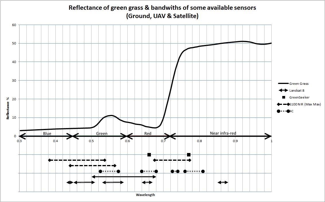
Figure 1. Reflectance of green grass & bandwidths of some available sensors including Ground (GreenSeeker), UAV (S100 NIR & 4C) & satellite (Landsat 8).
Conclusion
Innovation surrounding UAV use in agriculture is on the rise. We can expect data quality to improve, prices to fall and more robust workflows.
On farm experimentation with UAV has shown data to be useful but attention should be on sensors and data processing.
All data sources need to be considered when information is required. It's not a case of you use one or the other.
Contact details
Ben Boughton
'Gilroy' Moree NSW 2400
0428548688
ben@satamap.com.au
@BenBoughton1
GRDC Project Code: GRDC funded Nuffield Scholarship,
Was this page helpful?
YOUR FEEDBACK