Dune discharge seepage areas in the South Australian landscape – what are they, have they changed over time & can we better manage them for improved productivity?
Author: James A Hall | Date: 10 Feb 2015
James A Hall, Juliet Creek Consulting Pty Ltd.
Keywords: seepage areas, dune discharge, scald, deep drainage, low permeability, sodic soil, Blanchetown Clay, Loxton-Parilla Sand, summer weeds, high-water-use plants.
Take home messages
- Lower water use on sand dunes is the likely cause of increased discharge seepage in adjacent swale areas.
- Continuous cropping and the excellent weed control of modern farming systems, especially of summer weeds, are the likely causes of lower water use on dunes.
- The best advice is to use rainfall where it falls, and utilise high-water-use options on dunes to fix the problem.
Background
There has been growing concern in South Australian cropping regions about the increasing occurrence, severity and extent of localised discharge seepage areas (e.g. Murray Valley Standard 2015; Lawson and Tonkin 2014; ABC Rural 2014). The seeps of concern, and those analysed by this paper, occur adjacent to sand dunes in dune–swale landscape areas. They are not associated with regional groundwater, and typically have low initial salinity levels (but these can increase over time). This paper will cover the processes involved in their formation, how they differ from other wet areas, why they are becoming more noticeable, what can be done to reduce their severity and extent, what are the associated land degradation concerns, and how such areas may be better managed. Of interest are observations that the problem is most noticeable and severe in continuous cropping paddocks on properties with excellent weed control; in particular, control of summer weeds on sand dunes.
Much is known about the soil and regolith materials and processes that contribute to dune seepage areas, largely as a result of the work done by the South Australian Soil and Land Program on the 25-year ‘State Land and Soil Mapping Program’ (see Soil and Land Program 2007; Hall et al. 2009; Maschmedt 2002). Soil and landscape property datasets have also been modelled to produce maps of ‘dune seepage potential’ for South Australia (unpublished data).
Processes
Localised seepage of water from sand dune areas to adjacent swales and flats has been known, for a very long time. The process involves sand dune water; other than that stored as soil or deeper regolith moisture, lost as evaporation, used by plants or released by leaves as transpiration. The residual water is the deep drainage that moves beyond the rootzone and into the deeper layers of sand dunes. This deep drainage can then either continue to drain downward, eventually reaching the underlying aquifer or, where there are impeding materials, discharge into adjacent swale soils (Figure 1). It is this very last phenomenon that is discussed in this paper.
Table 1. Classes of hydraulic conductivity for soil and regolith materials – indicating permeability rates (from McKenzie et al. 2002).
|
Class |
millimetres / hour |
millimetres / day |
|---|---|---|
|
extremely slow |
0.01 |
0.24 |
|
very slow |
0.1 |
2.4 |
|
slow |
1 |
24 |
|
moderate |
10 |
240 |
|
fast |
100 |
2400 |
|
very fast |
1000 |
24000 |
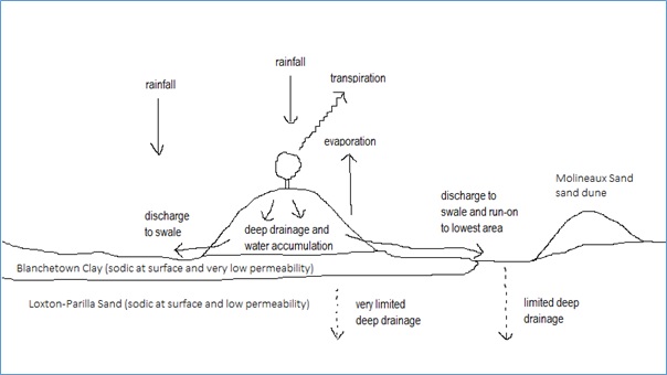
Figure 1: Water movements and simplified Mallee stratigraphy. “Water seeps from the dunes perched on clay layers of low permeability, producing watertables beneath the swales where soluble salt contents are high. Evaporation produces saline surfaces. Reclamation involves reducing seepage with deep-rooted species on the dunes” (Victorian Resources Online). It is quite probable that the core of the sand dune could become saturated when deeper drainage is restricted by an underlying low permeability layer, so providing a store of water for later discharge.
When discharge onto or into swale soils leads to saturation right to the land surface,owing to the presence of underlying low permeability layers, serious problems can ensue (Table 2). Persistent waterlogging can lead to an inability to seed the area or to crop failure or poor growth. Lack of cover begins the cycle of salt accumulation in the soil surface and possible erosion by water and wind. If the unprotected area is subsequently deflated by wind erosion, the resulting loss of topsoil can result in a more-or-less permanent scald (an area devoid of plant growth where plants are difficult to establish).
Salt build up within the seepage area occurs because salts from the sand dune core are carried with the excess dune water into the discharge area. The non-sandy Mallee soils of swale areas typically also contain significant salts in subsoil layers, and these salts too can be mobilised. (Figure 2). In bare areas, a vertical cycle of salt movement occurs, where salts are brought to the surface via capillary action when soil moisture evaporates at the land surface (especially during the heat of summer), which is subsequently washed downward with winter or other significant rains. However, if the soil is permanently saturated, downward movement of salts may be limited. (Figure 2). This type of salinity is similar to ‘dry saline land’ (where soil salinity is not associated with saline watertables) (Chapter 12, Salinity in Maschmedt 2002), and has also been described as ‘transient salinity’ (see Rengasamy 2002). This is in contrast to the primary and secondary soil salinity caused by shallow saline watertables, which are often of great extent (e.g. in the Upper South East of South Australia). Secondary salinity is further categorised into ‘irrigation salinity’ and ‘dryland salinity’, the latter being a somewhat unfortunate term, as it is easily confused with ‘dry saline land’. Dryland salinity is meant to signify areas of highly saline land caused by the clearance of deep-rooted perennial trees and their replacement with the shallow-rooted annual crop plants utilised by dryland farming, causing additional deep drainage below the rootzone into the underlying groundwater and a subsequent rise in the level of the saline watertable. (For further explanations of salinity in the landscape see Hall et al. 2009 (pp 83–85)).
Soil salinity levels are the key to understanding the impacts on plant growth of salinity (Table 2), rather than whether the salinity is associated with a saline watertable or not (although remediation options can differ according to process). Also of note is the fact that waterlogging greatly increases the deleterious effect of salinity (at any given salinity level) on plant growth (Barrett-Lennard 2003; Table 3).
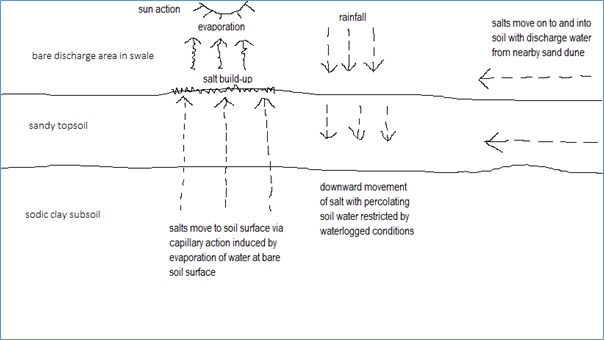
Figure 2: Salt movement within a swale soil in a bare discharge seepage area.
Table 2. The impact of soil salinity levels on plant growth (adapted from salinity attribute classification tables in Appendix 5 of Hall et al. 2009).
|
Salinity class |
Vegetative indicators and effects |
Indicative ECe* (dS/m) (* saturation paste EC) |
|---|---|---|
|
Cropping land |
||
|
low (Class I) |
no evidence of salt effects |
<2 (surface) <4 (subsoil) |
|
moderatey low (Class II) |
some wheat yield depression, deep-rooted horticultural and pasture legumes effected, but no vegetative indication |
<4 (surface) 4–8 (subsoil) |
|
moderate (Class III) |
halophytes usually evident (e.g. sea barley grass), many field crops and lucerne affected |
4–8 (surface) 8–16 (subsoil) |
|
moderately high (Class IV) |
halophytes predominate, too salty for most field crops and lucerne |
8–16 (surface) 16–32 (subsoil) |
|
Land too salty for field crops |
||
|
high (Class V) |
land dominated by halophytes with bare areas, land will support highly salt tolerant productive species such as puccinellia and tall wheat grass |
16–32 (surface) >32 (subsoil) |
|
very high (Class VII) |
>50% bare ground, land is too salty for any productive plants and supports only extreme halophytes |
>32 (surface) any (subsoil) |
|
extreme (Class VIII) |
bare salt-encrusted surface |
any |
It is also worth mentioning that there are many processes and mechanisms that can cause agricultural soil to be wet. Dune seepage is just one of them. The causes of wet areas vary from localised wetness owing to water run-on and poor drainage, to sloping land intersecting groundwater at a ‘break-of-slope’, to the presence of near-surface regional watertables.
Table 3. Degree of waterlogging and impact on plant growth (from susceptibility to waterlogging attribute classification table in Appendix 5 of Hall et al. 2009).
|
Drainage class |
Description (after significant rainfall) |
|---|---|
|
Cropping land |
|
|
rapidly drained (Class I) |
soil is wet for no more than several hours |
|
well drained (Class II) |
soil is wet for no more than several days |
|
moderately well drained (Class III) |
soil is wet for up to one week |
|
imperfectly drained–A (Class IV) |
soil is wet for several weeks |
|
Land too wet for field crops |
|
|
imperfectly drained–B (Class V) |
imperfectly drained soil that is prone to saturation early in the season |
|
poorly drained (Class V) |
soil is wet for several months |
|
very poorly drained (Class VII) |
soil is wet for most of year |
|
inundated (Class VIII) |
land is permanently under water |
Technically all water causing saturation below the land surface is ‘groundwater’ whereas, an ‘aquifer’ is the permeable geological material that contains or transmits groundwater. Nonetheless, the seasonal water that causes waterlogging in many South Australian texture-contrast soils is not generally thought of as ‘groundwater’, although it is sometimes called a ‘perched water table’. The water in swale seepage areas is similar to this perched water, and is perched upon a low permeability subsoil or substrate directly below the soil.
The mallee soils of swale areas were known as solonised brown soils in the old Australian Great Soil Group scheme (Stace et al. 1968). This signified a soil containing an accumulation of salts. They often have relatively high subsoil salt contents owing to a low rainfall incidence restricting drainage and flushing of salts, as well as often having low permeability sodic clay subsoil or underlying substrate that further restrict drainage. A sodic clay soil is one with excess sodium ions attached to clay particle surfaces, causing dispersion of clay particles when wet and the blockage of soil pores and hence impeded drainage. Under the newer Australian Soil Classification (Isbell 2002), swale soils often classify as Calcarosols and Sodosols; while in the scheme designed for South Australian soils (The Soils of Southern South Australia, Hall et al. 2009) they especially occur in Soil Groups A, B and G.
Dune seeps can occur in cropping areas anywhere that dunes occur. This especially includes the SA Murray Mallee, but also central, eastern and northern Eyre Peninsula, as well as northern Yorke Peninsula and parts of the Lower North.
The materials that cause restricted deep drainage in the SA Murray Mallee are Blanchetown Clay and Loxton-Parilla Sand. Both are sodic at their surface when forming part of a soil or a soil substrate. In particular, the Blanchetown Clay impedes drainage owing to very low permeability. Moreover, the name Loxton-Parilla Sand can be a bit of a misnomer. Although it always contains significant amounts of sand, it commonly textures as a sandy clay or sandy clay loam, and so can also significantly impede drainage. Of great interest is the fact that similar materials occur in similar positions and environments across South Australia. For example, Blanchetown Clay equivalent materials are common in the swales of dune–swale landscapes on Yorke Peninsula, the Lower North and Eyre Peninsula.
The dunes of the dune–swale systems of South Australia’s cropping districts typically occur as linear dunes (the jumbled dune areas have most often been left uncropped). They comprise wind deposited sands, that have generally been reworked from local and exotic wind and water deposited sediments. They typically contain a mixture of siliceous and carbonate material, with the carbonate material often leached to depth. Such sands are also often non-wetting. This can be particularly severe in bleached siliceous sand, where non-wetting properties can occur to depth. Many episodes of wind erosion since European settlement and clearing have resulted in a loss of topsoil and a spreading of dune material. Nutrient holding capacity on dune sands is very low, while water holding capacity is limited, especially when soils are non-wetting.
Cropping on dune soils has always been a marginal economic exercise; while it has been advocated for many years that dune soils should be managed separately from swale soils. However, this is not always practical, especially with modern farming machines and systems. Modern farming systems also allow for excellent weed control, including summer weeds on sand dunes (which once were very difficult to eradicate). As noted earlier, it has been observed that the increased incidence and severity of dune discharge seepage sites seem to coincide with continuous cropping systems (as opposed to more traditional farming systems) with excellent weed control. This leads to the conclusion that less incident water is being used upon sand dunes with these farming systems, and that the increased residual water is discharging on to swale areas. In some cases this may be beneficial, but not where excess water is resulting in persistent waterlogging and even bare scalds. The worst discharge situations are likely to occur where excellent summer weed control on dunes coincides with a large area of dunes relative to swales, with underlying very low permeability clayey materials (Figure 3). The larger the area of dunes in relation to swales, the worse the problem is likely to be. In the extreme situation where dune water is virtually not utilised upon dunes at all and is subsequently discharged to swale areas, and dunes occupy 50% (or more) of total area, then swales have to effectively deal with double the water they receive in rainfall! Very large dunes are also likely to cause problems. It is also likely that dune cores will become saturated and store water for subsequent, delayed discharge.
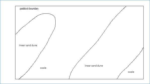
Figure 3: Aerial view of a paddock where sand dunes comprise 50% of total area, a substantial issue for swale areas if little of the rainfall on dunes is utilised in place.
Management of seepage sites and conclusion
Two main approaches could be taken to rectifying scalded discharge areas. The first is to manage the scald as a separate area, with the main priority to use-up soil water and prevent evaporation from the land surface. This could be achieved by growing any suitable vegetative cover on the discharge site (e.g. tall wheat grass or puccinellia) and by planting high-water-use trees or shrubs on the margins of the site. (Saltland Pastures for South Australia, Craig Liddicoat and Jock McFarlane 2007). The main problem with this approach is that it does not tackle the cause of the problem, which is low-water-use on adjacent dunes. The best approach would be to manage the offending sand dunes separately to the rest of the paddock, with deep-rooted, high-water-use perennials being the most effective. Neither approach, however, is likely to fit neatly into a modern farming system. The last approach is ‘not to alter management practices’, and leave the discharge areas as sacrifice areas. (There is also the possibility of utilising the excess water discharging into swale areas for other purposes (e.g. for stock water or irrigation)). However, such a tactic would result in unsightly, degraded areas at the worst affected sites. Lastly, the quicker such sites are dealt with the easier rehabilitation will be. Old, degraded sites take considerably more effort to restore.
The best advice is to use rainfall where it falls (Michael Brougham, pers. comm.) because the land lost to seepage (i.e swales) is potentially much more productive than the dune soils where the detrimental water originates from (i.e. dunes).
Acknowledgements
I would like to thank the following people for contributing their knowledge and observations on seepage areas: Michael Brougham, Kym Haebich, Chris McDonough, Tanya Morgan, Steve Richmond and Felicity Turner.
References
ABC Rural (2014). Article: Saline seeps causing headaches for South Australian grain growers. By Clint Jasper, ABC Rural, posted Dec 16 2014, including radio interview with farmer Kevin Jasper. See http://www.abc.net.au/news/2014-12-16/sach-mallee-dune-seeps/5970238.
Barrett-Lennard, E.G. (2003). The interaction between waterlogging and salinity in higher plants – causes, consequences and implications. Plant and Soil 253: 35–54.
Hall, J.A.S., Maschmedt, D.J. and Billing, N.B. (2009). The Soils of Southern South Australia. Geological Survey of South Australia, Bulletin 56, Volume 1; South Australian Land and Soil Book Series, Volume 1. Government of South Australia. See http://www.minerals.dmitre.sa.gov.au/publications_and_information/soils_information.
Isbell, R.F. (1996). The Australian Soil Classification – revised edition. Australian Soil and Land Survey Handbook Series, Volume 4. CSIRO Publishing, Collingwood, Victoria.
Lawson, B. and Tonkin, R. (2014). Article: Mallee dune seepages. In Mallee Matters (a quarterly communication for agriculture in the SA Mallee), Vol 3, July 2014.
Liddicoat, C. and Mcfarlane, J. (2007). Saltland pastures for South Australia. A do-it-yourself manual for the selection, establishment, management and evaluation of saltland pasture systems. Department of Water, Land and Biodiversity Conservation on behalf of the Sustainable Grazing on Saline Lands sub-program of Land, Water and Wool (a joint initiative of Australian Wool Innovation Ltd and Land and Water Australia), Government of South Australia. See http://lwa.gov.au/products/px071257.
Maschmedt, D.J. (2002). Assessing agricultural land. Agricultural land classification standards used in South Australia’s land resource mapping program. Soil and Land Information, Government of South Australia. [Available on the DVD, Regional land resource information for southern South Australia (2007), Soil and Land Program, Government of South Australia. See http://www.environment.sa.gov.au/Science/Information_data/soil-and-land/describing-soil-land/sa-format and follow link to ‘CD and DVD products’ pdf].
McKenzie, N., Coughlan, K. and Cresswell, H. (2002). Soil physical measurement and interpretation for land evaluation. Australian Soil and Land Survey Handbook Series, Volume 5. CSIRO Publishing, Collingwood, Victoria.
Murray Valley Standard (2015). Article: Dune issues seep in. Murray Valley Standard newspaper, Jan 8 2015, p 22, Murray Bridge SA.
Rengasamy, P. (2002). Transient salinity and subsoil constraints to dryland farming in Australian sodic soils: an overview. Australian Journal of Experimental Agriculture 42(3): 351–361.
Soil and Land Program (2007). Regional land resource information for southern South Australia. DVD ROM. Soil and Land Program, Government of South Australia. See http://www.environment.sa.gov.au/Science/Information_data/soil-and-land/describing-soil-land/sa-format and follow link to ‘CD and DVD products’ pdf.
Stace, H.C.T., Hubble, G.D., Brewer, R., Northcote, K.H., Sleeman, J.R, Mulcahy, M.J. and Hallsworth, E.G. (1968). A Handbook of Australian Soils. Rellim Tech. Pubs., Glenside, S.A.
Victorian Resources Online. ‘5.1.3 Linear dunes sub-dominant (mostly south east of Big Desert, Millewa) (/ 5. North Western Dunefields and Plains (DP) / 5.1 Calcareous dunefields)’. Landform information on dune–swale mapping units with sub-dominant calcareous dunes in north-western Victoria. Accessed Jan 15 2015. See http://vro.depi.vic.gov.au/dpi/vro/vrosite.nsf/pages/landform_geomorphological_framework_5.1.3.
Contact details
James Hall
0447 400 092
julietcreek@gmail.com
Was this page helpful?
YOUR FEEDBACK