A 'how to' for getting soil water from your EM38 field measurements
Author: Jenny Foley, Department of Natural Resources and Mines | Date: 05 Mar 2013
Jenny Foley, Department of Natural Resources and Mines
Take home message
EM38’s are an easy to use geophysical surveying instrument that provide a rapid measure of soil electrical conductivity (EC). Soil calibrations or qualitative assessments can be used to convert this to estimates of soil water in the root zone. This information is vital to farm management decisions based on accurate knowledge of soil PAW.
 Introduction
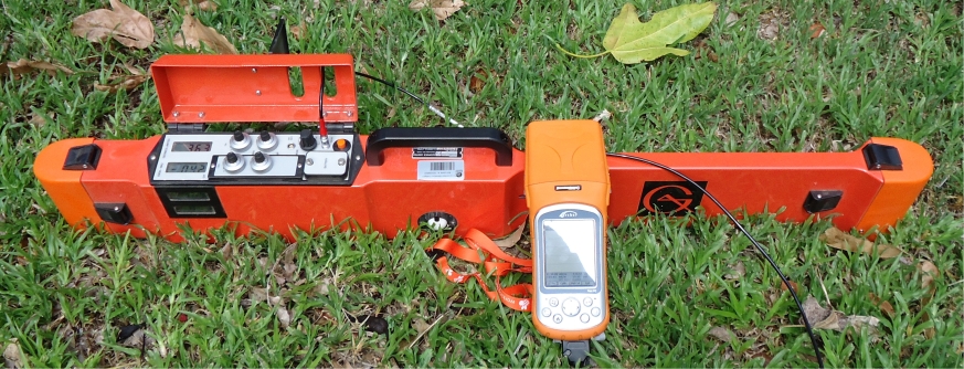
Despite an extensive range of monitoring instruments now available to us, measuring paddock soil moisture is still a considerable challenge. Among the suite of instruments currently available, one that stands out and is increasingly being used by researchers and agronomists is the EM38 (Geonics Ltd., Ontario, Canada). This electromagnetic induction instrument is proving to have significant application potential for determining soil properties useful in precision agriculture and environmental monitoring. It is now commonly used to provide rapid and reliable information on properties such as soil salinity and soil management zones, both of which relate well to crop yield. It is also used in a wide number of agronomic and environmental applications to monitor soil water within the root zone. It provides an efficient means to monitor crop water use and plant available water (PAW) in the soil profile throughout the growing season so that informed management decisions can be made e.g. the application, timing and conservation of irrigation water and fertiliser. EM38 datasets have also proved valuable to test and validate water balance models which are used to extrapolate to other seasons, management scenarios and locations.
EM38’s are easy to use, lightweight, and provide rapid, numerous measurements over large areas without the need for ground installations or destructive sampling. New advances in EM38 technology now allow a direct connection to computer based data acquisition systems to record survey and GPS receiver information.
What do they actually measure?
The EM38 measures apparent electrical conductivity (ECa) in the root zone. Different orientations, coil offsets and depths measured (ground level or above) are used to obtain a range of sensing depths. The ECa reading is a weighted average across a depth range, weighted according to the respective depth functions of the different coil orientations and spacing’s. In the vertical dipole (EM38 placed upright on ground surface) the reading is weighted strongly towards soil attributes at around 0.3-0.6 m depth, declining exponentially to approximately 1.5 m depth (1 m coil spacing). When the device is placed in the horizontal dipole mode (EM38 sideways on ground surface) the reading is weighted strongly towards soil attributes at the surface 0-0.3 m, declining exponentially to approximately 0.75 m.
Targeted readings can be taken for tracking soil water movement and redistribution at depths of most interest to the operator by simple choice of dipole, coil spacing or height above ground.
What affects the measurements?
The strength of the induced current is determined by the ECa of the soil which is mainly a function of the soil’s water, clay and salt content. These soil attributes influence ECa in a complex and interrelated way. As the percent of clay increases in a soil (particularly the smectite dominant swelling clays such as the Vertosols found extensively in agricultural lands of northern Australia) the water holding capacity also increases and so too the ability to hold salts in solution. A site/soil specific calibration is necessary to differentiate the effects of these variables on ECa.
For the purpose of tracking water movement and re-distribution throughout the growing season, repeated measures at the same locations within the paddock (with salt and clay remaining constant) allow for any changes in ECa to be attributed to changes in soil water content.
How do we get a paddock calibration for estimating soil water?
Calibrations allow us to convert EM38 readings to cumulative soil water estimates via a linear regression (Figure 1). To develop a calibration, concurrent EM38 readings and soil volumetric soil water need to be measured across a range of wet to dry conditions. This can be achieved by sampling a range of moisture conditions in close by (same soil) paddocks e.g. sampling fallow, cropped or pasture/treed areas. Calibrations can also be developed for a single paddock or farm site through time. As few as 6 sampling points gathered across a range of soil moistures may be sufficient to develop a calibration that provides a good estimate of soil water (in uniform soils).
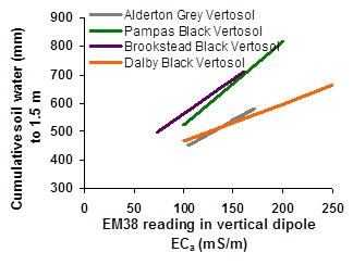
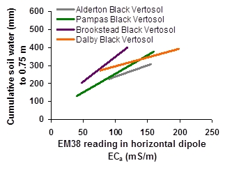
Figure 1: EM38 readings calibrated against soil water for southern QLD Vertosols - showing variation between sites and soil types for both vertical (1.5 m) and horizontal (0.75 m) dipoles
A case study – estimating crop water use throughout an irrigated cotton growing season
In this study we used the EM38 to track soil water under an irrigated cotton crop for part of the growing season. ECa readings were calibrated against cumulative soil water for a range of wet and dry field conditions (Figure 2a). Soil cores were taken with a soil coring rig to 1.5 m depth and bulk density and gravimetric water content sampled in 0.2 m increments. Cumulative soil water was calculated in vertical dipole (mm to 1.5 m) and horizontal dipole (mm to 0.75 m) or as a function of height-above-ground if the EM38 was raised above ground for readings. Several adjacent paddocks were sampled to get a good range of moistures, including post harvest in zero till sorghum (at crop lower limit, CLL); our experimental PAWC plots (at drained upper limit, DUL); bare fallow (filling); the cotton crop after an irrigation (wet to saturated); and native vegetation (very dry).
EM38 readings were taken in clusters of 192 readings in rows and furrows using 6 dipole and height-above-ground combinations to target specific depths in the soil. Readings were taken at head, mid and tail positions before and after irrigations and throughout the growing season. Sampling was rapid, taking less than 2 hours to take all 600 readings; including loading and unloading the vehicle between sampling positions (head, mid and tail) and temporarily laying a string sampling framework in each position so that repeated measures occurred on the same spot each time. Results in Figure 2b clearly show us the variability in total infiltration after irrigations (head gets more water than mid or tail), the degree of over watering (at head of paddock and this was accompanied by visible plant water logging), and the crop water use over the growing season.
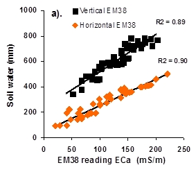
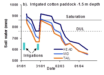
Figure 2: Detailed EM38 measurements of soil water, distribution of irrigation water and changes to the water balance of an irrigated cotton crop, during a summer growing season on a Black Vertosol at Pampas, a) calibration used to estimate soil water, and b) change in soil water to 1.5 m at head, mid and tail positions in the paddock
What about soil texture variability in my paddock?
When we measure ECa across a paddock with variable soil texture, differentiating soil water content from other attributes becomes increasingly complex. An increase in ECa may be due to an increase in water content, or salinity or it may be due to an increase in clay (which is often accompanied by increased water and salt). Some care must be taken when interpreting readings in these conditions. Applying a paddock calibration to derive soil water becomes hazardous unless detailed mapping of soil zones, verified by soil surveying, is undertaken and separate calibrations developed for the different soil zones. This requirement, however, is similar for other methods of soil water measurement.
How does temperature affect the EM38 readings?
Soil temperature is dependent on time of the year, local climate and paddock conditions. Due to the temperature dependency of ECa, a soil correction factor needs to be used to adjust readings for soil temperature variations. This is only required if measurements occur throughout the year. Tables of representative correction factors have been published for sites within the northern grain growing region. Refer to Table 2 in Huth and Poulton (2007) for temperature corrections.
What if I don’t have a paddock calibration (qualitative versus quantitative use)
The EM38 can be used to enhance and support our instinct, experience and knowledge. By simply walking in the paddock during fallow and cropped conditions with the EM38, changes in soil water and ECa can be observed (readings are instantaneous and can be viewed continuously on screen). Over time the operator will come to know both the degree of paddock variability, and the expected ECa for a range of moisture conditions for a particular paddock or whole farm. This range will encompass typical readings when the soil is drier e.g. harvest and potentially at CLL, and typical readings when the soil is wetter e.g. at sowing, and potentially when the soil is close to DUL. If an absolute value of PAW (mm) is not required, then this ‘qualitative’ approach is often sufficient. From this type of application, a very useful qualitative estimate can be made about the PAW and how full the ‘bucket’ is.
For example, let us use the soil and calibration from Figure 2 (Black Vertosol from Pampas). We already know from our studies the DUL, theoretical CLL (1500 kPa) and corresponding ECa readings (given in Table 1). However for a qualitative assessment we need only know that the typical range of ECa values we have observed over a range of soil moisture conditions ranges from ~100-190 mS/m. If we then, for instance, go out into the paddock and find the readings are around ~145 mS/m, we know the paddock ‘bucket’ is half full, i.e. at 50% of PAWC. We don’t need a calibration, simply a range of ECa values across wet to dry soil moistures, to then estimate the percent of PAWC available at any time.
Table 1: Soil water estimated from the vertical EM38 calibration on a Black Vertosol at Pampas
|
Soil moisture |
Cumulative mm to 1.5 m |
ECa reading mS/m |
|
DUL |
770 |
188 |
|
CLL |
525 |
100 |
|
50% PAWC |
648 |
143 |
References
Huth NI, Poulton PL (2007) An electromagnetic induction method for monitoring variation in soil moisture in agroforestry systems. Australian Journal of Soil Research 45, 63-72.
Contact details
Jenny Foley
Department of Natural Resources and Mines
Ph: 0745291270
Fx: 0746881193
Email: jenny.foley@dnrm.qld.gov.au
Reviewed by Dr Neil Huth, CSIRO, Toowoomba, Queensland.
GRDC Project Code: ERM000002,
Was this page helpful?
YOUR FEEDBACK
