The use of unmanned aerial vehicles (UAVs) in agriculture - regulations, challenges and opportunities
The use of unmanned aerial vehicles (UAVs) in agriculture - regulations, challenges and opportunities
Author: James Rennie and Heinz de Chelard | Date: 17 Feb 2015
James Rennie and Heinz de Chelard, Australian UAV Pty Ltd.
Keywords: unmanned aerial vehicles, drones, aerial photography, aerial survey, Civil Aviation Safety Authority, CASA.
Take home messages
- There are many opportunities presented by UAV technology in agriculture with image acquisition and survey data.
- Flying UAVs requires certification by CASA (both existing regulations and those about to be announced).
- There are inherent risks to the UAV and other airspace users.
- A UAV is a tool to lift a camera/payload to generate data.
- The technology is commercially available now and being used globally.
Background
This paper will highlight the opportunities and constraints associated with Unmanned Aerial Vehicle (UAV) technology in the agricultural sector. The focus of the paper is on the challenges and opportunities in methods to capture data rather than the interpretation of that data for agricultural uses.
UAV technology has come of age over the past 2-3 years. Confluence of camera technology, GPS, navigation systems and, most importantly, battery technology has driven an exponential interest and use in the technology. There are now approximately 250 Civil Aviation and Safety Authority (CASA) licenced operators in Australia, up from 35 in the beginning of 2013.
When examining the potential opportunities and uses of the technology in the agricultural sector it is important to understand the limitations, risks and technical challenges together with the benefits.
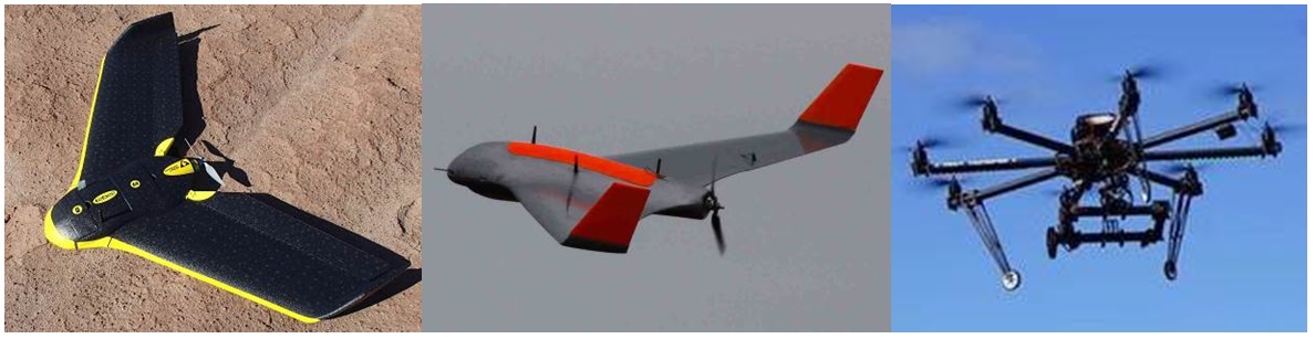
Firstly, what are we talking about in terms of a UAV (or drone)? The most commonly referenced UAV is the multi-rotor copter (Figure 1 right). With an endurance of up to 30 minutes and heavy payload capacity these have been used widely in the research sector. For example, Australian UAV currently operates this aircraft on behalf of the Victorian Department of Primary Industries carrying their thermal and multi-spectral cameras. In agriculture these multi-rotor UAVs are well suited to small areas, low level flight and heavy cameras. Their use in broad scale commercial agricultural applications is severely compromised by the lack of endurance. Given this constraint the remainder of the paper will focus on the fixed-wing aircraft.
Whilst the vast majority of media has been associated with the use of the multi-rotor copters the real commercial opportunities lie with the fixed-wing aircraft. Capable of carrying a range of cameras and sensors the fixed-wing aircraft can capture photography over about 700ha a day for the small aircraft and over 1200ha a day for the larger platforms. These UAVs therefore offer commercially viable broad scale data capture and presentation in a scaled, referenced aerial map form.
The flexibility of the UAV platforms enables cameras to be exchanged to capture different image bands for use in presentation of true colour, near infra-red or Normalised Differential Vegetation Index (NDVI) maps, with pixel densities of 2-4cm.
This high resolution imaging presents opportunities in mapping crop health, weeds and assets.
Data capture – what can be achieved?
Images
It is important to view a UAV as a tool to carry a camera to generate data, the UAV itself is not the product. When considering a UAV for a task the following requires consideration:
- What would you like to achieve from the final output?
- What ground pixel resolution and camera spectral type is required?
- What area of coverage requires capture and how often?
- What spatial accuracy of the output is required?
- What is the timeframe between capture and product delivery?
Once these questions have been resolved there are further considerations such as topography, take-off and landing areas available and economies of scale, it is worth considering whether it is cheaper to hire a manned aircraft for the task.
Using one UAV as an example, the eBee (Figure 1 left) is a very common off-the-shelf UAV and arguably the market leader globally. This small UAV is relatively easy to fly and carries a range of cameras specifically designed for agricultural applications. Capture rates of up to 600ha a day at 3.6cm/pixel resolution are possible and processing of 600ha will take in the order of three days on a 64gb RAM computer. As with all the commercial photography processing software the eBee “PostFlight” package produces a single image rectified for use in any GIS software package. There are also options to present the maps as a Google kml (file format used to display geographic data in an Earth browser such as Google Earth or Google maps) or through web service providers like PA Source.
Custom aircraft (eg. X8 in Figure 1 middle) has a 2.5m wingspan and can carry heavier payloads and multiple cameras over larger areas. However they also require more manual flying ability of the operator and, if multiple cameras or a higher resolution camera is used, it takes longer to process the data. Collecting 2gb of image data per flight is not unusual.
For most agricultural applications the absolute accuracy of the photography generated by the on-board GPS, without any post processing or ground control, is in the order of 1-3m in the horizontal. With ground control in place or the use of one of the new Real Time Kinematic (RTK) GPS enabled aircraft the accuracy is in the 5-10cm range. We have found that, except in research applications on small plots, 1-3m accuracy is suitable for most agricultural tasks that are not seeking elevation data.
Surface models
A bi-product of the photogrammetry software is the production of a digital surface model. With ground control in place (or the RTK GPS equipped UAV) a 600ha property can be flown in one day and a high resolution (3.6cm point density) surface model produced with a vertical accuracy of 5-10cm. Whilst this is comparable to, or better than Light Detection and Ranging data (LiDAR), it relies on low vegetation cover. Whilst trees can be manually removed, tall grasses or crops pose significant challenges.
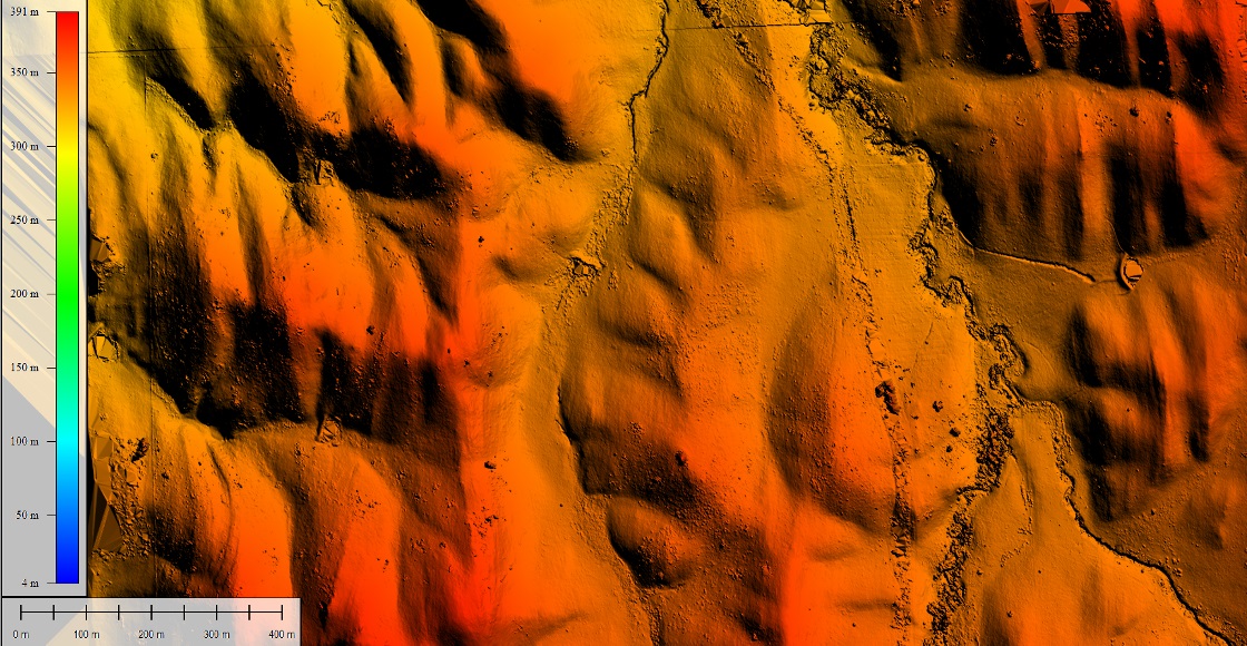
Figure 2. Digital surface model demonstrating elevation relief over a property.
These digital surface models are particularly useful in design of irrigation channels, drainage and farm plan contour maps.
Regulations
Not anyone can pick up and fly a UAV. UAV use in Australia is regulated by the Civil Aviation and Safety Authority (CASA). The regulations stipulate that any commercial operator of a UAV (ie. any use of a UAV in your line of work) requires an individual to hold a Controller Certificate and the organisation they represent has to have an Operators Certificate.
Gaining a Controllers Certificate either requires the completion of the Private Pilot’s Licence theory exam or a course delivered by a certified UAV training organisation. An Operators Certificate is issued by CASA following the preparation of an Operations Manual that includes all the company safety systems, maintenance manuals and processes.
Some key points in relation to the use of all UAVs include:
- No flying above 400ft (120m) above the ground without an area clearance issued by CASA.
- No flying within 3nm (about 5km) of an aerodrome unless an area clearance has been issued by CASA or the organisation undertaking the flight has been granted an blanket exemption.
- No flying within 30m of a person or building.
- The operator must maintain the UAV within line of sight at all times.
Whilst these are the key points in the regulations there are many more to be aware of and available on the CASA website www.casa.gov.au .
CASA is in the process of re-writing the regulations relating to UAV use. The key regulation change relates to the use of UAVs <2kg in weight. The latest indication is that this will effectively only free up the use for small multi-rotor UAVs, therefore precluding any real relaxation of use in the agricultural sector.
UAV risk – case study
So, why are CASA worried about UAVs in rural areas over private properties? Whilst it might seem farfetched that a UAV operating below 400ft over a private property in rural Australia could pose a risk to general aviation, there is ample cause for concern.
As anyone working in the rural sector would understand there are many uses for manned aircraft in agriculture, most of which require flying low to the ground. In 2013 there was a near miss incident reported between one such crop duster and a UAV. The combination of a fast moving agricultural aircraft and a UAV, albeit a small one, could be catastrophic. It is for this reason that CASA recognises the requirement that all operators should be appropriately trained and licenced.
The risks increase significantly the larger the UAV becomes. With the X8 (Figure 1) weighing in at over 3.5kg and containing batteries that may cause fire on impact there is significant potential to cause damage to property or persons on the ground when used incorrectly. If engaging contractors to undertake work it is important to check CASA certification, that safety systems are in place and public liability insurances are current.
Risks to UAV - eagles
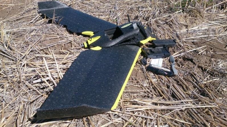
Maintaining a UAV in line of sight has safety benefits for the operator too. Whilst operating throughout Australia our experience has been that at least once a day there will be an attack by a wedge-tailed eagle. Whether the eagles believe the UAV to be prey or a threat is not known, however the attacks are persistent and damaging. Any operator that sends a UAV beyond line of sight will lose it to an eagle before long (sometimes even when it is within line of sight, Figure 3).
Conclusion
Our experience has shown that UAVs can be used safely in the agricultural sector for a range of tasks including monitoring crop health, weed mapping, irrigation/drainage design and farm planning. Where short turnaround time between data capture and delivery/analysis is required the UAV technology provides a valuable tool to assist decision making.
There is no doubt that UAVs will become a regular tool in the effective management of agricultural production throughout the globe. The integration of rapid data capture and turn-around time meets many of the requirements of broad acre agriculture in an age when precision agriculture and automation are becoming the norm. Whilst at present there is significant research in the use of UAV technology, mainly in the development of agricultural specific cameras, there are commercially available products that are working now.
As battery technology and computer processing power improve we will see the two constraints to the use of large scale economical agricultural UAVs diminish.
Contact details
James Rennie
Australian UAV Pty Ltd, PO Box 6106, Cromer, Vic 3193
0497 070 576
James.rennie@auav.com.au
#AustralianUAV
Was this page helpful?
YOUR FEEDBACK