Overcoming wind erosion during and following drought
Overcoming wind erosion during and following drought
Author: Chris McDonough (Insight Extension for Agriculture) | Date: 18 Aug 2021
Take home messages
- Wind erosion during extended drought periods presents challenges for all growers in maintaining soil cover and stability, with high risk for applying rehabilitation ground works.
- Sands can quickly stabilise with conservation farming practises and reduced grazing, but changes are needed to current benchmarks and strategic management planning to minimise major degradation.
- The practical use of satellite-based monitoring tools are being explored to give growers/advisers more predictive, interactive localised information to make more informed management decisions.
Background
Wind erosion has been a feature of mallee farming landscapes since settlement. The good news is wind erosion has dramatically reduced over the last 20 years with most growers adopting conservation farming techniques. However, extended drought periods reduce a growers’ ability to grow and maintain adequate soil cover due to lack of rain and increased pressures from livestock and pest animals. This means that farms are highly vulnerable to wind erosion, often with no easy solutions available due to seasonal unpredictability.
The two key factors that influence wind erosion in the Mallee are:
- The natural erodibility or susceptibility of the soil.
Heavy soils contain relatively high levels of fine clays (>20%) which help hold soil particles together to form stable aggregates which reduce the erodibility. They are naturally more fertile and readily grow and retain organic matter in surface layers, which increases biological activity. Bacteria acts like glue within the soil, while fungi also wrap around particles holding them together (Figure 1).
Most mallee sands have less than 5% clay content and are naturally infertile, with very low water holding capacity, organic matter, and biological activity. This makes them extremely erodible in periods of strong winds. As coarse sand particles bounce along the surface they expose and displace the most fertile portion of the soil – the clay fines and organic matter – which are quickly lost in raised dust. Wind tunnel research has shown that the portion of soil lost can be 5 to 10 times as fertile as the soil from which it has come (Leys, Butler et al. 1993).
- The protection of soil from erosion hazard influences through farm management.
Soil protection from wind erosion is achieved by maintaining adequate soil cover and by enhancing soil aggregation. Fifty percent soil cover is used as a general benchmark, but this may vary due to several considerations such as:
- Anchored cover, particularly with some pulse residues over summer.
- A higher standing stubble can greatly reduce wind speed at ground level.
- A sandy soil on a rise will require higher cover level than less exposed heavier soils.
When soil aggregation is broken up through cultivation or heavy trafficking by grazing, feral animals or machinery, all soils (including loams and clays) become vulnerable to wind erosion. Conversely, conservation farming practices that encourage high levels of organic matter turnover will greatly increase microbial activity (even within very sandy Mallee soils), binding particles together and provide substantial protection from wind erosion.
Recent extended drought creates significant issues.
Unfortunately, since the wet season of 2016, most mallee districts across the Southern Region experienced 3-4 years of late season breaks, well below average rainfall and low spring rainfall. This made it extremely difficult to achieve adequate soil protection. Initially, on more erodible soil types, such as sandy rises, but also on more loamy flats as the grazing and pest pressures increased. Strong winds sand-blasted crops when seedlings, and the dry springs produced little water for vegetative growth to both protect the soil surface and to feed vital soil microbes.
Repeated years of drought made it difficult to re-establish soil cover, and mechanical rehabilitation strategies such as levelling or even re-sowing areas often lead to further degradation when follow up rainfall didn’t eventuate. Small vulnerable areas soon became catalysts for far greater blowouts, often with very few options for remediation and leaving long-term damage.
The severe impacts of wind erosion place our soil resources, the environment, farming businesses and our rural communities under extreme pressure with some irreversible consequences. To address this, the GRDC has invested in a project to identify key knowledge gaps of growers in the SA, NSW and Victorian Mallee and the Upper Eyre Peninsula, developing a series of grower case studies on best practice for soil preservation.
New approaches and management practices need to be adopted to prevent and minimise these impacts from occurring. This project aims to provide practical strategies and solutions for growers within a range of farming systems and low rainfall environments to best protect their farms from soil degradation and rehabilitate land safely back into production.
Method
The project began by conducting a survey across each of the four project districts of Eyre Peninsula, SA, Vic & NSW Mallee, to assess key issues and knowledge gaps regarding wind erosion management through drought periods for growers in the Low Rainfall Zone (LRZ) of the Southern Region. Initial findings based on the 44 grower survey responses and case study grower interviews has helped steer the direction of ongoing project activities.
The project has selected eight growers (two from each district), representing a range of farming systems and situations for in-depth site monitoring of wind erosion rehabilitation and measurement of ground cover satellite data. These are being developed into a series of case studies that will capture:
- The management system and identify the factors that have caused a reduction in ground cover
- The strategies used to re-establish ground cover and the relative success of the strategies
- A measure of the change in ground cover levels over the season and where the trigger points lie for decision making to prevent erosion, including seasonal impacts
- Grower comments and recommendations on the success of each strategy
These case studies will provide growers with easily accessible insights, improved benchmarks, and strategies for overcoming these significant issues in very uncertain times.
Results and discussion
Wind Erosion Survey Report results
Key findings from the initial Wind Erosion Survey Report for GRDC revealed the following:
- The estimated average cost of erosion per grower surveyed was $80,000. The average farm size was 5000ha with an average annual rainfall of 300mm.
- Sandy soil types are the most susceptible to wind erosion through drought periods, accounting for 75% of eroded land according to all growers surveyed, but only 50% of area in NSW.
- Lack of winter and spring rainfall is considered the greatest cause of wind erosion by respondents, alongside strong summer, and autumn winds.
- Erosion was most likely to occur in the second and third year of dry conditions, not so much the first.
- For all the regions surveyed, crop establishment is the main driver for cereal wind erosion issues through dry conditions, followed by management of poor residue areas.
- 75% had livestock in their farming system. Residue/feed management over the summer and autumn months presented the greatest erosion challenges but continued throughout whole drought period.
- Respondents indicate that the four greatest factors contributing to wind erosion are previous blowout areas, cropping vulnerable paddocks then experiencing poor follow up rains, overgrazing and livestock camping on hills/vulnerable areas.
- The most frequently used successful management strategies are no-till/narrow points, confinement feeding, early sowing, establishing specific crop varieties, major soil grading/levelling, reducing stock numbers and reseeding damaged areas. Leaving eroding paddocks out of production generally did not work.
- 64% of respondents indicated that the most challenging factor when trying to manage wind erosion, is a fear of making things worse if the right follow up conditions are not received. The lack of time/labour (43%), appropriate machinery (30%) and financial resources (23%) also feature highly in the challenges faced. Growers also expressed difficulties in knowing what to do (30%), as well as a lack of options that suit their situation (20%).
- Overwhelmingly, respondents use their own visual assessment observations to monitor ground cover levels. Nine percent are using remote sensing and no respondents use paddock measurements (step pointing/photo standards).
Recommendations to overcome identified knowledge gaps and assist growers in managing wind erosion through drought are:
- New strategies to adequately protect eroding land through drought periods, and to safely restore and rehabilitate eroded land during seasonal, as most current options cannot be achieved without high exposure to risk. These need to be targeted based on the soil and crop types in each region.
- The redefinition of benchmarks for both livestock, crop choices and management decisions that take a longer-term view of the potential for poor outcomes given extended drought periods.
- Practical, accessible, objective assessment tools that support sound and accurate grower decision making for soil cover levels. There may be an opportunity to develop remote sensing tools into interactive applications to monitor and warn growers of impending risks.
- More accurate predictive medium-range seasonal climate forecasts in the low rainfall zone to aid appropriate decision making.
- An improved understanding of how changes to climatic patterns will impact future management strategies and enterprise mixes.
- Adoption of affordable virtual fencing, or other applicable technologies, to mitigate risks of erosion caused by livestock camping on vulnerable areas.
- The impact of kangaroos on soil erosion in NSW has been devastating. Collaborating growers are exploring the implementation of strategic fencing lines to overcome this issue but need support.
Early monitoring findings – Dry Aggregation (%DA) differences – even in sand
Site monitoring has clearly shown the benefits conservation farming can bring to protect these soils against wind erosion. Table 1 shows direct comparisons between the erosion risk of nearby soils with different management practices. While all low erosion risk sites benefited from growing and maintaining ground cover (>49%), retaining stubble and excluding grazing increased %DA of topsoils from 0 to 28-35%. This is a result of increased microbial activity binding particles together.
Table 1. Selected comparable monitoring sites that were all bare and blowing in 2019.
Adjacent Sandy Sites | Description | Clay | Dry Aggreg. | Soil Cover | Erosion Risk |
|---|---|---|---|---|---|
Nildottie 1 | Bare sand blowout | <1.0 | 0 | 5 | High |
Nildottie 2 | Medium grazed sandy rise on 2020 Stubble | 1.1 | 10-20 | 47 | Medium |
Nildottie 3 | No-graze sand, 2020 chicken manure, cross sown, resulting in strong standing stubble | <1.0 | 28 | 70 | Low |
Borrika 2 | Bare Sand Blowout after levelling & crop in 2020 | 2.6 | 13 | 22 | High |
Borrika 1 | Strong Stubble after levelling and crop in 2020 | 1.9 | 25 | 62 | Low |
Cleve 1 | Rolling bare sand deposit area | <1.0 | 4 | 3 | High |
Cleve 2 | Sand covered with good 2020 cereal rye stubble | <1.0 | 35 | 49 | Low |
Mildura 2 | Clayey sand, high grazing burden on 2020 stubble | 9.4 | 19 | 13 | High |
Mildura 1 | Clayey sand, low grazing pressure on 2020 stubble | 8.8 | 25 | 63 | Low |
Livestock producers within this project have said they need to change their benchmarks for how long stock should remain in paddocks, as paddocks need to be managed according to their most vulnerable soil types, taking into account the possibility of extended drought into following seasons. They also expressed the importance of being better prepared with on-farm feed reserves, confinement feeding facilities and being more responsive to managing trigger point areas before wind damage takes hold. These and other important strategies will be further explored, analysed, and reported on through the remainder of the project.
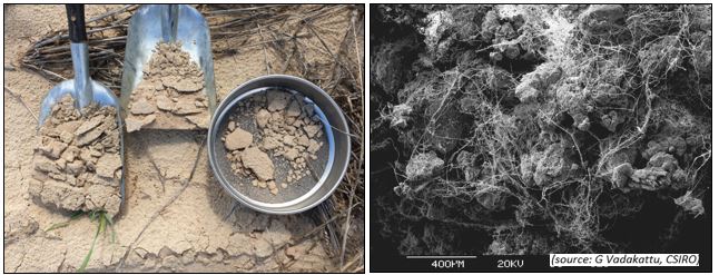
Figure 1. Rapid DA increase in Cleve site sand, with image of fungi binding sandy soil particles together
Satellite monitoring tools
One clear finding from the wind erosion survey is that growers aren’t using soil cover estimation tools to benchmark estimates but rely on general visual estimations and experience to base their decisions on. More accurate, accessible and locally relevant and warning systems are needed, with links to suitable management strategies.
CSIRO has supported the development of the GEOGLAM RAPP tool that provides regional soil cover maps. The data is currently based on a large 500m pixel size and used to indicate changes between years and present trends and warnings (Figure 2). This can indicate areas that are vulnerable to wind erosion at a given point in time. Figures 3 and 4 show comparative trend lines between different seasons that may be used to gain an early indication of potentially adverse outcomes.
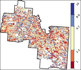
Figure 2. Total Vegetation Cover Decile () map of LGA Loxton Waikerie, June 2021.
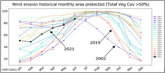
Figure 3. Seasonal comparisons of district average Soil Cover Protection for LGA Loxton Waikerie.
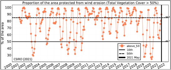
Figure 4. Proportion of areas protected from wind erosion through time. LGA Loxton Waikerie June 2021.
Conclusion
Soil degradation in Mallee environments are a key challenge for growers during extended drought periods. These conditions prevent the conservation of critical soil cover levels and increase the physically damaging impacts of livestock and pest animals. The most challenging factor when trying to manage wind erosion, is a fear of making things worse if the right follow up conditions are not received.
The GRDC project “Practical tactics to improve ground cover and ensure soil preservation following successive low rainfall seasons” with Mallee Sustainable Farming is currently exploring the issues and practical solutions across low rainfall areas in four sub-regions. Over the next year, eight grower case studies will be produced compiling monitoring results and strategies for improving ground cover along with other extension activities.
Acknowledgements
The research undertaken as part of this project is made possible by the significant contributions of growers through both trial cooperation and the support of the GRDC and MSF project team, and the author would like to thank them for their continued support.
Useful resources
Schober Case Study Sand Rehabilitation at Borrika Video
References
Leys, J. F., P. Butler and C. McDonough (1993). 'Wind Erosion at Borrika in the South Australian Murray Mallee' (Department of Conservaton and Land Management: Sydney)
CSIRO (2021). Total vegetation cover soil protection, Region: LGA Loxton Waikerie (DC) SA, June 2021), GeoGlam Rapp for Australia
Contact details
Chris McDonough
C/o Post Office Loxton North SA 5333
0408 085393
cmcd.insight@gmail.com
GRDC Project Code: MSF2010-002SAX,