Bureau of Meteorology developments in long-term forecasting accuracy – the implications for autumn sowing
Author: Claire Yeo (Bureau of Meteorology – Agriculture Decision Support) | Date: 20 Feb 2024
Take home messages
- Research by the Bureau of Meteorology’s Agriculture Program and engagement with the grains industry has shown a need for insights that connect short-term weather forecasts to long-term climate forecasts.
- The Agriculture Program continues to improve the grains industry’s understanding of long-term forecasts that look beyond 7 days, and aims to positively impact on-farm business management and grains-specific decisions such as autumn sowing.
- This paper provides one example drawn from the range of case studies developed by the team that demonstrate a service that is available to help inform key decisions. The case studies outline the approach the team has used to analyse day-to-day model performance, which in turn helps to ground truth the long-term forecast for improved accuracy.
- We invite growers and advisers to keep up to date with the analysis of the forecasts by subscribing to the grains climate video briefings (Bureau of Meteorology Agriculture YouTube playlist), and by contacting the team via email at agriculture@bom.gov.au, or in-person at field days and seminars.
- Additional work currently being developed within the Bureau will further assist in growers’ long-term planning.
Background
The Agriculture Program has recently increased its service to the agriculture sector with investment in the Agri-Climate Outlooks project from GRDC and other rural research and development corporations. Research conducted by the Agriculture Program has found that there is a need for insights that bridge the gap between short-term forecasts (0–7 days) and long-term probabilistic climate forecasts, hereafter referred to as long-term forecasts (one week to months). Based on this need, the decision support service as part of the Agriculture Program, aims to provide advisers and growers a comprehensive risk assessment for weather and climate decision making specifically. This objective is achieved through analysis and research that includes verification and case studies of weather and climate events utilising expertise within the Bureau.
This is demonstrated in a specific Victorian case study from Christmas 2023 (see below). This case study demonstrates how the decision support service bridges the gap between the Bureau’s 7-day forecasts and the Bureau’s long-term forecasts (that utilise the Bureau’s single ACCESS-S – Australian Community Climate and Earth-System Simulator – model), by providing the agriculture sector with additional information to support on-farm high-value decisions.
The insights that the Agriculture Program captures, also informs research conducted by the Bureau i, including current research with outputs from the ACCESS-S model that may help to further bridge the gap between short-term forecasts and long-term forecasts in the 1–4-week period. This is being done for both temperature and rainfall, and proposed products show the range of possibilities up to 30 days out via ‘box and whisker’ plots.
Method
Agriculture decision support
The decision support service provides tailored insights to the agriculture sector to support adviser and grower decisions by providing weather and climate information that connects short-term weather with slower-moving climate drivers and long-term forecasts.
As professional meteorologists at the Bureau of Meteorology, members of the Agriculture Program aim to develop and understand the complex science of weather and climate, but with a dedicated agricultural lens. This gives us the best insight into connecting the physical interactions of the atmosphere with the computer-modelled scenarios. In the past nine months, the decision support service has developed the following tools for the grains industry.
- Regular video briefings for each of the three GRDC grain-growing regions. In the period between February 2023 and December 2023, the decision support service produced 29 grains videos, released to the Bureau’s new dedicated Agriculture YouTube playlist. Every video briefing update explains how the short-term weather forecast will transition into the longer-term climate forecast to help bridge the gap between the two.
- Tailored video briefings – We have tailored video briefings to compare the Australian ACCESS-S climate model to international long-term climate models. This ensures we are providing a range of scenarios and providing insights on the most likely outcome based on verification and performance of the multi-models.
- Background discussions on rainfall probabilities – Analysis of how the rainfall probability distribution of the ACCESS-S model influences the forecast map output, and how to interpret this for decisions on the ground.
- Short-term weather alerts – Sending weather alerts for significant weather events that bridged the gap between short and long-term expectations beyond five days. This was done by utilising severe weather analysis experience within the team.
- Trialling various products – These include a conversational video explaining and myth-busting El Niño Southern Oscillation (ENSO) to uplift broader agricultural awareness and knowledge.
- Verification and case studies – Regular forecast verification, while also compiling regional-specific case studies from across the country.
Results and discussion
Victoria case study
In the lead up to 25 December 2023 when harvest was well underway in central and southern Victoria, a surface trough and low-pressure system developed over northern Victoria. These two weather systems dragged large amounts of tropical moisture from northern Australia over the region. Because of both the spatial and temporal differences in the short-term models in the lead-up to the rain event, Bureau forecasters used a blend of various models. This forecast, issued on 21 December 2023, is shown in Figure 1 below. At the same time, the ACCESS-S model forecast for December was indicating 30-40% chance of exceeding the weekly median rainfall for most of central and western Victoria. In other words, the ACCESS-S model suggested a drier than average December for Victoria, in contrast to the 7 day forecast. This is also shown in Figure 1.
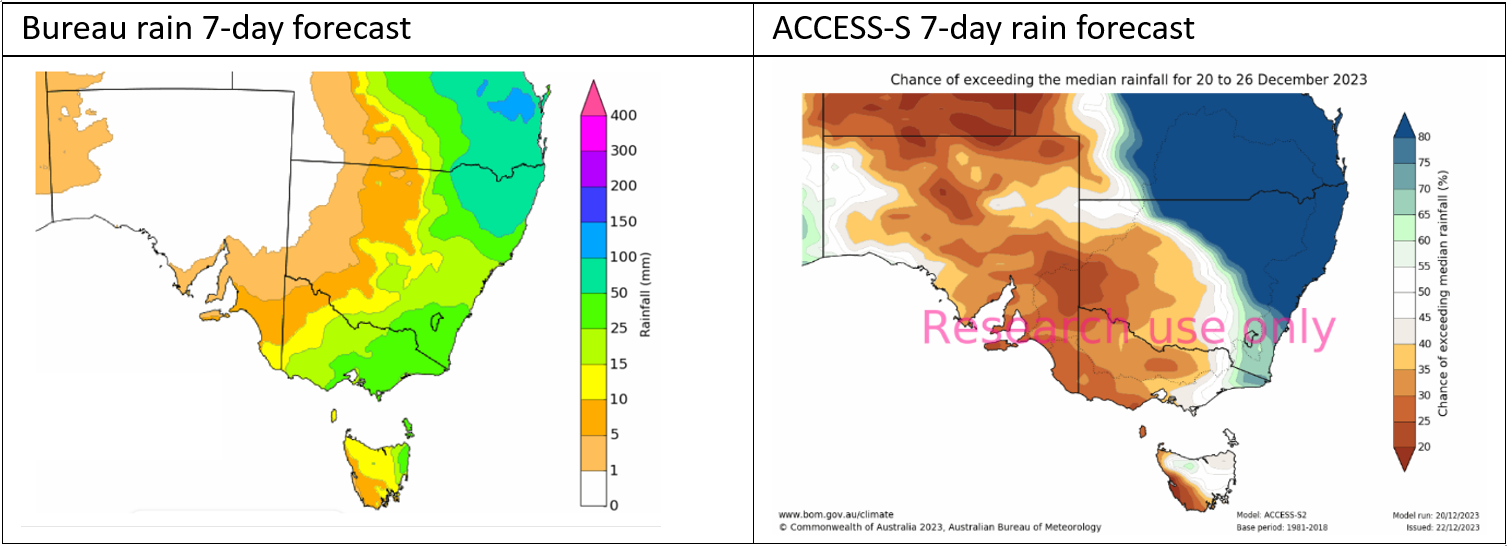
Figure 1. Comparison of the forecasts issued 21 December 2023.
In the left panel of Figure 1, the Bureau rainfall outlook was forecasting broad 7-day totals of 25–50mm across central Victoria as being the most likely scenario. The median rainfall for that week in December is approximately 10mm, including Bendigo, and so, this forecast was well above the weekly median.
In the right panel of Figure 1, ACCESS-S was forecasting that the same seven days would most likely be drier than median (30-40% chance of having above median rainfall). No doubt, grain growers in Victoria used the 7 day forecast to expedite harvest where possible, in an attempt to avoid the rain damage. As a result of this rain event, Bendigo received 46mm, and more than 100mm at locations to the north-west. The monthly average rainfall for Bendigo is 46mm.
This demonstrates how the overlap between short-term and long-term models can differ due to variations in computer model physics and resolution, discussed further below.
Insights into short-term and long-term models
The Bureau’s rainfall outlook uses a blend of short-term forecast models, which can provide temperature or rainfall amounts in the coming days. On the other hand, long-term models cannot be this specific, due to small random changes that can amplify into different weather patterns [1]. Rather, long-term forecasts, such as the ACCESS-model, being probability-based, are designed to be used as one of several planning tools within risk management and decision-making. The greatest benefits of using Bureau long-term forecasts will accrue from use over several seasons or years.
Further differences arise between short-term models and long-term models due to differences in computer power required in running millions of complex mathematical equations, both temporally and spatially. Differences also arise due to the analysis and comparison of various short-term models that is undertaken by meteorologists, rather than only considering one model output.
Simply, from the grower or public perspective, these two products are telling different stories, and in some cases, the Bureau’s short-term rainfall outlook can appear to be at odds with the long-term probabilistic model forecast.
The decision support service provides analysis and insight regarding the short and long-term model outputs tailored to the agriculture sector. The grains climate videos produced as part of the decision support service also include discussions around the spread of ACCESS-S rainfall probabilities. These probability distributions demonstrate how the output of the ACCESS-S model derived the specific percentage chance of above median rainfall. These background explanations help to provide context as to why the long-term model may be forecasting neutral conditions by looking at the spread of possible outcomes. Positive feedback from advisers and industry representatives has shown that the inclusion of these additional insights can help to explain outlooks by going beyond what is just presented on the maps.
Link to autumn 2024 outlook
As growers approach the autumn 2024 season, insights from the decision support service may support weather and climate-based decisions for sowing, as an example. Our briefings and continued engagement with the grains industry into the autumn months will aim to provide an additional layer of analysis to support decisions that are rain and temperature sensitive. Further details of the autumn 2024 seasonal outlook will be made available at the oral presentation.
Conclusion and further work
With agriculture industry investment, the Bureau is working to improve the transition between the short-term and long-term forecasts. The Bureau’s Agriculture Program will continue to convey key insights of foundational research as the Bureau considers opportunities to operationalise these findings based the needs of grain growers and other farmers. The decision support service, through understanding the complex science of weather and climate, aims to provide targeted insights to inform high-value agriculture decisions. The meteorologists in the Agriculture Program use their experience to bridge the gap between short-term and long-term forecasts through video briefings, verification, and case studies.
The Agriculture Program will continue to engage with the agriculture industry on an ongoing basis, and identify opportunities, such as through the Agri-climate outlook project to provide direct relevant weather and climate analysis and insights tailored to the needs of the agriculture sector. The insights captured from the agriculture sector will inform work to understand model bias, verification, and model physics in international climate models where appropriate. We would like growers and advisers to keep up to date with the analysis of the forecasts by subscribing to the grains climate video briefings, and by contacting the Agriculture Program via email at agriculture@bom.gov.au, or in-person at field days and seminars.
Acknowledgements
The research undertaken as part of this project is made possible by the significant contributions of growers through both trial cooperation and the support of the GRDC, the author would like to thank them for their continued support.
The Bureau of Meteorology, in partnership with Agricultural Innovation Australia (AIA) are delivering the ACO project, which involves collaboration across 10 rural Research and Development Corporations.
References
About the long-range forecasts
Bureau of Meteorology Agriculture YouTube playlist
Long-range weather and climate
Contact details
Claire Yeo
Bureau of Meteorology
Claire.Yeo@bom.gov.au
Was this page helpful?
YOUR FEEDBACK