Exploring new and alternative lime sources for managing soil acidity in South Australia
Exploring new and alternative lime sources for managing soil acidity in South Australia
Take home messages
- Potential new lime sources are being identified using an assessment of geological layers across South Australia, analysis of quarries that are currently used for other purposes and new lime sources have been used in past trials.
- Lime demand by region can be estimated using a spatial geographic model with recent land use, soils prone to acidity and estimates of acidification rate by crop and rainfall zone.
Background
Management of soil acidity through liming is commonplace amongst many areas of South Australia. There has been considerable extension and communication around rates, types and sources of lime through the GRDC SA Acid Soils project, however growers in some areas note that there are difficulties in accessing lime, particularly over the last three years. Lack of local lime sources can influence growers to limit application rates, and this can potentially result in increasing soil acidity through non-application of lime or application of lime at suboptimal rates, driven by the increased cost of accessing lime from further afield. This GRDC-funded project aims to explore and identify potential options for local lime source development and undertake a commercial feasibility study, through:
- examining likely demand for lime on a regional and district basis over the next decade, identifying any potential shortfall in lime supplies in the short and/or longer term, examining alternative lime sources, and providing information to industry to develop and understand future opportunities in lime supply
- extension of the project findings to growers and the wider industry.
The outcomes of this investment will help to enable sustainable liming application and limit further acidification of South Australian agricultural soils.
Method
There were two key components undertaken as part of this project.
Lime supply options, now and into the future
A study of existing quarries, potential lime supplies and geological deposits which may be suitable in areas where lime supplies have been restricted and/or are close to where acidity is currently spreading will be undertaken. This is being carried out by John Keeling (JK Minerals Consulting) with support from the Department of Mines and Energy (DME). The project includes a desktop study, along with field work, including sampling and analysing existing and potential quarries. Assessments were, in part, focussed on areas where future lime demand is likely to increase or where lime availability tends to be limited, such as the Mid North, Mount Lofty Ranges, Southern Mallee and Eastern Eyre Peninsula. John has visited over 40 quarries and sampled and analysed these deposits.
Existing demand for lime
The demand for lime was estimated by upgrading the Department of Environment and Water soil acidification model – this included establishing a spatial model with recent land use data, areas at risk of acidification, and extent of subsurface and surface acidification (where data were available). The model can be used to estimate annual acidification rates and the required additional amounts for both regional and district targets.
A secondary component of this model is the examination of subsurface and surface soil pH levels, particularly in regions where lime supply is limited. This study is establishing new pH monitoring sites, re-testing existing sites and examining existing data to help improve the estimation of lime requirements. Monitoring sites have been GPS located and have been established on a 20m × 20m grid with 9–10 sampling points to enable repeatability.
This information will be used to develop a report describing lime demand for SA regions, production risk, potential and actual local supplies, and possible acidity expansion.
Lime use figures have been calculated from annual personal surveys undertaken with agricultural lime companies through DEW by SARDI staff.
Results and discussion
Lime supply options
Current lime use and supply
Agricultural lime use has increased from a low point of around 70 000t in 2007 to close to 300 000t in the last few of years. Limited supply, particularly in the Mid North, may have restricted amounts to some extent. Three new agricultural lime suppliers have enabled the Mid North lime amounts to increase substantially in 2024. However, the loss of one major Adelaide Hills supplier in 2025 may impact on lime use in this region going forward.
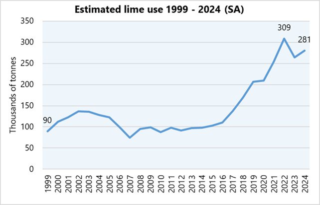
Figure 1. Actual agricultural lime use (‘000 of tonnes) by year for the whole of South Australia between 1999 to 2024 (Data source: DEW lime use survey).
Future options for lime supply
Availability of future lime supplies will depend on the location, the region and pricing structure. There are basically three main types of agricultural lime. The first type is linked to unconsolidated sediments including coastal dunes, old coastal dunes and cliffs, shell grit and lake deposits. This source often does not require crushing and often only requires to be sieved. Unfortunately, these only occur in more coastal areas or where the Bridgewater formation or calcareous sands have moved inland. The second group is the soft and variably cemented carbonates common in the South-East and Murraylands and are often crushed. The third supply is where harder, often rock material, is broken down by crushing, sieving or grinding frequently as a by-product to producing road rubble or some other coarser product. The harder supplies are more common in the Mid North and Mount Lofty Ranges region.
Table 1: Geological carbonate formation and key properties from current sources in SA (from Keeling, new sites as of 7 January 2025) –still being updated.
| Geological Formation | Geological Subunit | Rock type | Neutralising Value (%) | Current or historic sources | Potential new sites # |
|---|---|---|---|---|---|
| St Kilda Formation | Semaphore Sand | Lime sand | 77-96 | Little Sahara KI (23), Coffin Bay | |
| Shell grit | 86-89 | Port Parham, Port Prime (uncrushed) | Some deposits – quantity/ price issues | ||
| Bridgewater Formation | Unconsolidated Bridgewater Formation | Lime sand | 83-97 | McDonald pit, Port Lincoln (12), Cummins EP Limesand (14), Lake Leake (8), Foster Pit (7), Wiseman Pit (27), DeEstree Bay (19) | Central EP near Lock – calc dunes possible Areas along coast northern YP- calc dunes difficult access Hart Warooka – used in trial YP, Upper SE poss |
| Holocene carbonate lake deposits | Limestone, Dolomite or Magnesite | 82-99 | Lake Hawdon North (5), Salt Creek (6) Daly Head (3) - (particles disaggregate when wetted, extremely fine-grained) | Daly head YP - not used much | |
| Hytesbury Group shelly limestone | Gambier Limestone | Limestone | 92-100 | Marte Quarry (16), Telford Quarry (17), Bruhn Quarry (22) Naracoorte (20), Caroline (25), Kongorong (4) | |
| Dolomite | 97-104 | Tantanoola Quarry (26), Whitehead (24), GEM Burnda Road (15) | |||
| Calcrete | Limestone | 73-81 | Hartley Quarry (18), Cawte, Murray Bridge (9) | Bordertown – selling Tailem Bend – problems with quality | |
| Proterozoic Carbonate | River Broughton Beds | Dolomitic Limestone | 49 | Clare Quarry (10) | |
| Katunga Dolomite | Dolomite | 68 | Cleve (11) | ||
| Cambrian Carbonate | Angaston Marble | Marble (limestone) | 93-98 | Penrice Quarry (1) | Seelander and Barossa Quarries – selling |
| Kulpara Dolomite | Dolomite | 91 | Kulpara Quarry (21) | Wirrabara – variable site | |
| Forktree Hill Formation | Dolomite | 90 | Sellicks Hill Quarry (2) |
#report due end of Jan
Field work has been examining existing quarries and other samples to determine possible sites which may have agricultural lime capabilities.
Demand for lime
Annual acidification rate (AAR) model
Inputs include spatial coverages of land use from DEW (2020), acid prone soils and a calculation of AAR based on crop type and rainfall zone. AAR can be produced for a geographic area down to the hundred. In Table 2, examples of some AAR by crop and rainfall zone are shown. These have been generated using models that are accessible on the Acid Soil SA website (https://acidsoilssa.com.au/)
Table 2: Examples of annual acidification rates (AAR) calculated from the AAR calculator (Acid Soils SA website) across different crop types, rainfall zones, target yields and fertiliser inputs.
| Crop type | Rainfall Zone (mm) | Yield crop (t/ha) | Fertiliser (kg/ha) | AAR - sandy loam (kg lime/ha/yr) | AAR - loam (kg lime/ha/yr) | AAR- Clay loam (kg lime/ha/yr) | Version Calculator used |
|---|---|---|---|---|---|---|---|
| Wheat | 250-350 | 1.8 | DAP @50 | 62 | 42 | 32 | Harding and Masters |
| Urea @40 | |||||||
| Wheat | 350-400 | 3.2 | DAP @70 | 176 | 121 | 65 | Harding and Masters |
| Urea@140 | |||||||
| Wheat | 400-500 | 4.8 | DAP @100 | 284 | 191 | 99 | Harding and Masters |
| Urea@240 | |||||||
| Canola | 400-500 | 2.2 | DAP @ 75 | 272 | 198 | 145 | Harding and Masters |
| Urea@150, SOA@100 | |||||||
| Lentils | 350-400 | 1.7 | MAP 50 | 143 | 102 | 62 | Used Wurst variation |
Figure 2 highlights how acid prone areas are calculated, based on the state soil and land database, and highlights land use calculations for the Lower North district and are used to calculate AAR.
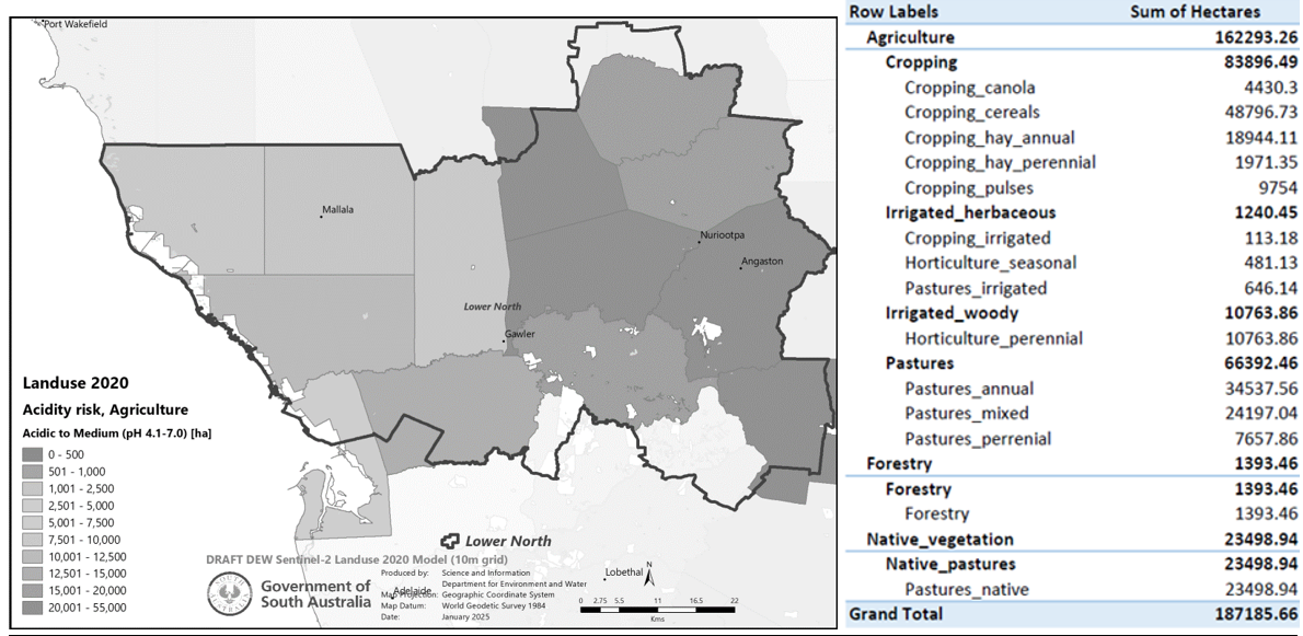
Figure 2. Acidity risk (in ha) mapped by hundred and an example of area by crop type in the Lower North region (DEW) – 2020.
For the Lower North district, annual acidification from land use in 2020 was determined to be equivalent to 20,326t of lime per year, assuming 100% neutralising value.
Subsurface and surface pH levels
Around 20 new data sets have been added to the DEW soil information data set. In addition, 20 pH monitoring sites have been established in areas where acidity may be an issue or is likely to develop in the future.
Two examples presented below show the pH monitoring sites established at Karte and Smithville in the Murray Mallee. Recent sampling has been undertaken to repeat this monitoring and determine if there are any trends to more acidic readings.

Figure 3. The soil pHCaCl2 (orange) and pHwater (blue) from monitoring sites established at Karte and Smithville, 2017 across the soil depth from 0 to 80cm.
Comparisions of lime quality and alternative products
Some new products have been tested in field trials including Warooka lime sand in the Sandilands trial and a low Effective Neutralising Value (ENV) on-farm source from north of Bute in the Bute trial. In addition, several alternative products to lime including clay, manure, biochar and gypsum have been trialled at various sites. Clay at around 100t/ha has been shown to significantly increase pH by around 1 pH unit at two sites to a similar extent to the medium rate of lime when compared to no amendment (control). Other products have only resulted in no change or only short-term minor changes.
Some comparisons have been made between dolomites and limes and between differences in Neutralising Value (purity) and Effective Neutralising Value (fineness). Findings of this work were reported in last year’s proceeding article and more information is being collected, with final sampling underway across several trial sites.
Conclusion
Future lime sources are being assessed in regions where supply is limited, or acidity is expanding. Along with lime demand calculated by land use over acid prone areas, a detailed assessment of potential requirements for lime has been made at a regional scale for South Australia.
Acknowledgements
The research undertaken as part of this project is made possible by the significant contributions of growers and the support of the GRDC, the authors would like to thank them for their continued support. We also acknowledge the lime companies who have provided information on lime use, samples and aspects of their quarry. Dr Nigel Wilhelm and Luke Simpson (SARDI) are acknowledged for management of the acidity trial sites, as are other members of the GRDC soil acidity project, in particular Brianna Guidera, Nigel Flemming and David Woodard.
Useful resources
Department for Environment and Water (2023). Soil acidity and lime use in South Australia – May 2023 (https://cdn.environment.sa.gov.au/environment/images/Soil-acidity-and-lime-use-in-SA-Information-Sheet-June-2023.pdf)
Keeling (draft) Exploring new and alternative lime sources to manage soil acidity in South Australia. Report prepared for SARDI as part of the GRDC project DAS2404-003RTX
GRDC Acid Soils Southern Region (https://acidsoilssa.com.au/)
Contact details
Brian Hughes
Nuriootpa Research Centre
PO Box 245, Nuriootpa
0429 691 468
brian.hughes@sa.gov.au
GRDC Project Code: DAS2404-003RTX, UOA2206-009RTX,