CliMate: a smart phone App for farmers
CliMate: a smart phone App for farmers
Author: David Freebairn and David McClymont, RPS Australia East | Date: 05 Mar 2013
David Freebairn and David McClymont, RPS Australia East
Take home message
Climate data and weather forecasts are both valuable in informing grain growers of system status (e.g. soil water, heat sum) and probabilities of future events (e.g. rainfall, temperature extremes).
Analyses are now available in an iPhone/iPad App, CliMate, and web based tools, providing ready access to site specific climate information.
We describes the rationale and application of mobile technology to provide a range of analyses using long term climate data for any Bureau of Meteorology (BOM) station in Australia. Recent weather data can be used to assess some elements of system status, to support on ground observations.
With the aim of being applicable to a wide range of agricultural industries, each analysis is based on answering a question posed in a generic in language, but specific to each application. For example, CliMate provides answers to questions asked by the user within the framework
“what is the chance of getting [greater than or less than] X [mm of rain, oC temperature, oC days heat sum] in Y days between two months?”
The user has to frame their questions about risk into this style of question.
Three types of information can be derived from long term weather data:
- Probability of future events based on long term climate data (so called “climatology”) using basic weather variables;
- Status of a soil at a point in time based on near real time data; and
- Probability of a future event based on “climatology” or available forecasts.
Results are calculated in real time based on weather data from 1949 to yesterday. Each analysis is presented as:
- the question;
- a short text answer;
- a “Fire Risk” chart; and
- a graphic and text providing an explanation about how the answer was derived;
CliMate has seven analyses that aim to cover cropping, pastoral, horticultural and other specialist industries where an understanding of risk associated with weather is important.
The initial screen allows the user to select any long term climate site in Australia. Data is sourced from the Silo database (http://www.longpaddock.qld.gov.au/silo/) which is maintained by Queensland Government’s Department of Science Technology, Innovation and the Arts (DSITIA), based on data from BOM.
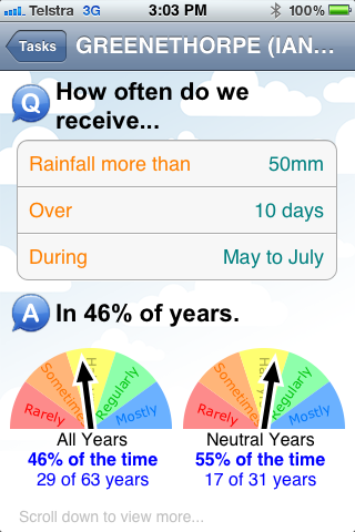
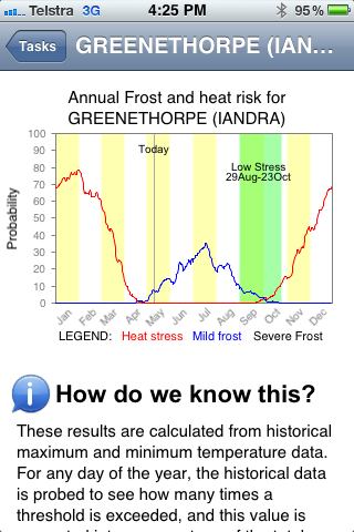
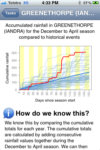
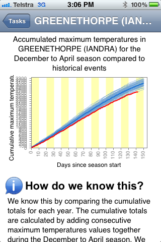
Several screen shots of CliMate are presented in Figure 1. The App sources climate data while in a mobile phone or wireless reception area and stores data until needed, even when not in a mobile reception area.
Typical applications
In order to demonstrate some capabilities of CliMate, examples of questions for each analysis are presented.
How often?
What is the change of a sowing event based on amount of rainfall over 5 days? How often is a heat sum achieved in a set period of time? What is the probability of temperature being below a critical level for germination or flowering?
How hot-cold?
When determining an ideal sowing date, when are heat and cold stresses lowest for an optimum flowing time?
Season’s progress?
When adjusting inputs during a season, how does the current season compare with previous conditions in terms of rainfall, temperature, radiation, heat sum?
How wet? N?
How much water and nitrate has been stored over the fallow? This may help adjust inputs to better match yield expectations. The nitrogen mineralisation estimate should be regarded as a relative to all seasons estimate, not an absolute estimate, as other factors such as previous crop history and residue are important (see CropMate for details).
How likely?
Based on sea surface temperatures in the Pacific and Indian Oceans, what is the probability of rainfall or temperature being [greater than, less than] the median or tercile value? The level of historic skill is also estimated.
How’s El Nino?
What are the key atmospheric and oceanic ENSO indicators suggesting? This information is obtained directly from the BOM.
How’s the past?
What is the big picture of previous weather, based on a graphical views of previous rainfall, temperature and radiation?
Climate links
Links to climate and related information sources and decision support tools.
Observations
Previous experience with a range of decision support tools has led us to conclude that:
- The simplest decision support tools are generally the most useful; and
- A rapid cycle of open questions and answers allows for the user to converge on insight into their locations climate variability.
The main advantage of having this information on mobile devices is that information is readily available where decisions are being made.


Figure 1: Four partial screen shots of CliMate. From top right and clockwise: How often do we receive rainfall; heat and cold stress probabilities; seasons progress in rainfall; and seasonal progress in temperature.
Availability
CliMate can be downloaded free from the App store – look for “Australian climate”
Contact details
David Freebairn,
RPS Australia East Pty
Ph: 07 3237 8820
Email: david.freebairn@rpsgroup.com.au
GRDC Project Code: MCV000028,
