Soil water – methods to predict plant available water capacity (PAWC) using soil-landscape associations
Soil water – methods to predict plant available water capacity (PAWC) using soil-landscape associations
Take home messages
- Plant available water (PAW) is a key determinant of potential yield in dryland agriculture. Obtaining a measurement or estimate of PAW can, therefore, inform crop management decisions relating to time of sowing, crop type or the level of fertiliser inputs.
- Estimating PAW, whether through soil coring, use of a soil water monitoring device or a push probe, requires knowledge of the plant available water capacity (PAWC) of a soil. PAWC characterisations for 26 soils in the Liverpool Plains are publicly available in the APSoil database, which can be viewed in Google Earth and in the SoilMapp application for iPad.
- PAWC for wheat within the Liverpool Plains range from 115 to 300 mm. PAWC for other crops may be similar (e.g. sorghum, cotton) or less (e.g. chickpea, mungbean). Variation in the observed PAWC can be linked to parent material, texture and subsoil constraints, with subsoil salinity responsible for the largest reductions in PAWC.
- Similarity in soil properties is key when extrapolating from these PAWC characterisation sites to a location of interest – the nearest characterisation is not necessarily the appropriate one.
- Conceptual models of relationships between soil properties, parent material and position in the landscape can assist with extrapolation and prediction of PAWC. This information is increasingly becoming available on-line, including soil-landscape and soil and land resources mapping of the Liverpool Plains on eSPADE.
- Digital maps of predicted soil properties at 90 or 100 m resolution are also being developed and can assist with identifying areas where the risk of subsoil salinity reducing PAWC needs to be considered.
- Work is currently underway to test and refine the PAWC prediction processes and make them more user-friendly.
- In the meantime, exploring the soil differences on your farm using these tools and the provided PAWC information may explain differences in performance between or within paddocks, help adjust yield expectations and inform management decisions.
Plant available water and crop management decisions
A key determinant of potential yield in dryland agriculture is the amount of water available to the crop, either from rainfall or stored soil water. In the GRDC northern region the contribution of stored soil water to crop productivity for both winter and summer cropping has long been recognized. The amount of stored soil water influences decisions to plant or wait (for the next opportunity or long fallow), to sow earlier or later (and associated variety choice) and the input level of resources such as nitrogen fertiliser.
The amount of stored soil water available to a crop - plant available water (PAW) – is affected by pre-season and in-season rainfall, infiltration, evaporation and transpiration. It also strongly depends on a soil’s plant available water capacity (PAWC), which is the total amount of water a soil can store and release to different crops. The PAWC, or ‘bucket size’, depends on the soil’s physical and chemical characteristics as well as the crop being grown.
Over the past 20 years, CSIRO in collaboration with state agencies, catchment management organisations, consultants and farmers has characterised more than 1000 sites around Australia for PAWC. The data are publicly available in the APSoil database, including via a Google Earth file and in the SoilMapp application for iPad (see Resources section).
A number of farmers and advisers, especially in southern Australia, are using the PAWC data in conjunction with Yield Prophet® to assist with crop management decisions. Yield Prophet® is a tool that interprets the predictions of the APSIM cropping systems model. It uses the information on PAWC along with information on pre-season soil moisture and mineral nitrogen, agronomic inputs and local climate data to forecast, at any time during the growing season, the possible yield outcomes. Yield Prophet® simulates soil water and nitrogen dynamics as well as crop growth with the weather conditions experienced to date and then uses long term historical weather records to simulate what would have happened from this date onwards in each year of the climate record. The resulting range of expected yield outcomes can be compared with the expected outcomes of alternative varieties, time of sowing, topdressing, etc. to inform management decisions.
Others use the PAWC data more informally in conjunction with assessments of soil water (soil core, soil water monitoring device or depth of wet soil with a push probe) to estimate the amount of plant available water. Local rules of thumb are then used to inform the management decisions.
The APSoil database provides geo-referenced data (i.e. located on a map), but the PAWC characterisations are for points in the landscape. To use this information to predict PAWC for the soil in a paddock of interest requires matching of a similar soil in the APSoil database. Similarities between soils are related to parent material and the conditions under which the soil formed, or the material deposited. This is often related to landscape position. Information on soil-landscape associations, therefore, provides an avenue to assist with PAWC prediction. The soil-landscape information is captured by the soil surveys undertaken by state government departments and other research organisations and is increasingly becoming available online.
This paper describes the concepts behind PAWC and outlines where to find existing information on PAWC. It discusses how soil-landscape associations can be used to inform extrapolation from existing PAWC sites and assist with prediction of PAWC, illustrated by examples from the Liverpool Plains.
Plant available water capacity (PAWC)
To characterise a soil’s PAWC, or ‘bucket size’, we need to determine (Figure 1a):
- drained upper limit (DUL) or field capacity – the amount of water a soil can hold against gravity;
- crop lower limit (CLL) – the amount of water remaining after a particular crop has extracted all the water available to it from the soil; and
- bulk density (BD) – the density of the soil, which is required to convert measurements of gravimetric water content to volumetric water content
In addition, soil chemical data are obtained to provide an indication whether subsoil constraints (e.g. salinity, sodicity, boron and aluminium) may affect a soil’s ability to store water, or the plant’s ability to extract water from the soil.
 Figure 1. (a) The plant available water capacity (PAWC) is the total amount of water that each soil type can store and release to different crops and is defined by its drained upper limit (DUL) and its crop specific crop lower limit (CLL)
(b) plant available water (PAW) represents the volume of water stored within the soil available to the plant at a point in time. It is defined by the difference between the current volumetric soil water content and the crop lower limit.
Plant available water (PAW)
Plant available water is the difference between the crop lower limit (CLL) and the volumetric soil water content (mm water / mm of soil) (Figure 1b). The latter can be assessed by soil coring (gravimetric moisture which is converted into a volumetric water content using the bulk density of the soil) or the use of soil water monitoring devices (requiring calibration in order to quantitatively report soil water content).
An approximate estimate of PAW can be obtained from knowledge of the plant available water capacity (PAWC) (mm of available water/cm of soil depth down the profile) and the depth of wet soil (push probe or based on a feel of wet and dry limits using an uncalibrated soil water monitoring device).
Knowledge of PAW can inform management decisions and many in the GRDC northern region have, formally or informally, adopted this. Several papers at recent GRDC Updates have illustrated the impact of PAW at sowing on crop yield in the context of management decisions (see e.g. Routley 2010, Whish 2014, Dalgliesh 2014 and Fritsch and Wylie 2015).
Field measurement of PAWC
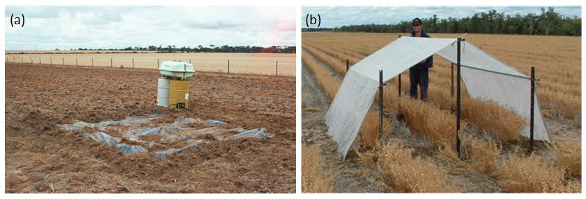
Field measurement of drained upper limit (DUL), crop lower limit (CLL) and bulk density (BD) are described in detail in the GRDC PAWC Booklet Estimating plant available water capacity (see Resources section). Briefly, to determine the drained upper limit an area of approximately 4 m x 4 m is slowly wet up using drip tubing that has been laid out in spiral (see Figure 2a). The area is covered with plastic to prevent evaporation and after the slow wetting up it is allowed to drain (see GRDC PAWC booklet for indicative rates of wetting up and drainage times). The soil is then sampled for soil moisture and bulk density.
The crop lower limit is measured either opportunistically at the end of a very dry season or in an area protected by a rainout shelter between anthesis/flowering and time of sampling at harvest (Figure 2b). This method assumes the crop will have explored all available soil water to the maximum extent and it accounts for any subsoil constraints that affect the plant’s ability to extract water from the soil.
Where to find existing information on PAWC
Characterisations of PAWC for more than 1100 soils across Australia have been collated in the APSoil database and are freely available to farmers, advisors and researchers. The database software and data can be downloaded from the APSIM website. The characterisations can also be accessed via Google Earth (KML file from APSoil website) and in SoilMapp, an application for the iPad available from the App store. The yield forecasting tool Yield Prophet® also draws on this database.
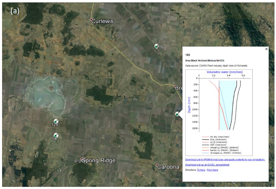
In Google Earth the APSoil characterisation sites are marked by a shovel symbol (see Figure 3a), with information about the PAWC profile appearing in a pop-up box if one clicks on the site. The pop-up box also provides links to download the data in APSoil database or spreadsheet format.
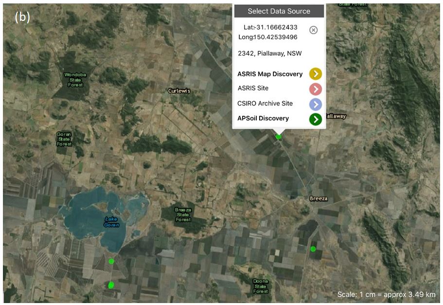
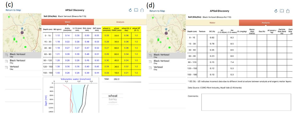
In SoilMapp the APSoil sites are represented by green dots (see Figure 3b). Tapping on the map results in a pop-up that allows one to ‘discover’ nearby APSoil sites (tap green arrow) or other soil (survey) characterisations. The discovery screen then shows the PAWC characterisation as well as any other soil physical or chemical analysis data and available descriptive information.
Most of the PAWC data included in the APSoil database has been obtained through the field methodology outlined above, although for some soils estimates have been used for drained upper limit (DUL) or crop lower limit (CLL). Some generic, estimated profiles are also available. While field measured profiles are mostly geo-referenced to the site of measurement (+/- accuracy of GPS unit), generic soils are identified with the nearest, or regional town.
Figure 3. Access to geo-referenced soil PAWC characterisations of the APSoil database via (a) Google Earth and (b) SoilMapp; (c, d) APSoil discovery screens in SoilMapp.
Factors that influence PAWC
An important determinant of the PAWC is the soil’s texture. The particle size distribution of sand, silt and clay determines how much water and how tightly it is held. Clay particles are small (< 2 microns in size), but collectively have a larger surface area than sand particles occupying the same volume. This is important because water is held on the surface of soil particles which results in clay soils having the ability to hold more water than sand. Because the spaces between the soil particles tend to be smaller in clays than in sands, plant roots have more difficulty accessing the space and the more tightly held water. This affects the amount of water a soil can hold against drainage (drained upper limit - DUL) as well as how much of the water can be extracted by the crop (crop lower limit - CLL).
The effect of texture on PAWC can be seen by comparing some of the APSoil characterisations from the GRDC northern region, as illustrated below (Figure 4). The soil’s structure and its chemistry and mineralogy affect PAWC as well. For example, subsoil sodicity may impede internal drainage and subsoil constraints such as salinity, sodicity, toxicity from aluminium or boron and extremely high density subsoil may limit root exploration, sometimes reducing the PAWC bucket significantly.
The crop lower limit may differ for different crops due to differences in root density, root depth, crop demand and duration of crop growth (Figure 4b, c). Some APSoil characterisations only determined the crop lower limit for a single crop. The crop lower limit for wheat, barley and oats are often considered the same and that of canola can be found to be similar as well, but care needs to be taken with such extrapolations as different tolerances for subsoil constraints can cause variation between crops.
A detailed explanation of the factors influencing PAWC is included in the Soil Matters – Monitoring soil water and nutrients in dryland farming book, a pdf of which is available for free online (see Resources section).

Figure 4. Select soil PAWC characterisations from Trangie and the Liverpool Plains.
(a) Sandy clay loam (APSoil No683) near Trangie NSW. Alluvial sediment formed on a meander plain of the Macquarie River more than 150,000 years ago. There is a higher proportion of sand, particularly in the surface of this soil which causes the lower PAWC.
(b) Vertosol on quaternary basaltic alluvium of Coxs Creek in the Liverpool Plains near Boggabri NSW (APSoil No122). Due to the high clay content the soil has a large PAWC, but its size depends on crop type.
(c) Vertosol on footslopes in Jurassic basalts and associated alluvium south of Goran Lake NSW (APSoil No128) has a large PAWC bucket exhibiting similar crop type effects. The mineralogy of the soil contributes to the very large PAWC.
Liverpool Plains soils and their landscape context
Within the Liverpool Plains cropping is practiced mainly on the heavy shrink-swell soils (Vertosols) of the plains and footslopes of basaltic origin. The high clay content of these soils means that many of the soils have relatively large PAWC of 200-350 mm. There are some subtle differences in response to clay mineralogy (related to parent material composition) and texture (e.g. inclusion of sand or fine gravel), which explain the variation within that range. Larger variation in PAWC within the Liverpool Plains is, however, caused by subsoil constraints, in particular subsoil salinity. These can limit root water uptake quite dramatically and can reduce PAWC by as much as 50%.
A report published last year (Verburg et al. 2017) describes fifteen new PAWC characterisations in the Liverpool Plains that were undertaken in recent years. These have enhanced the coverage of different soil types within the Liverpool Plains considerably. The location of new and existing PAWC characterisations in the Liverpool Plains is shown in Figure 5, along with some of the key PAWC profiles.
Extrapolating from these PAWC characterisations to predict PAWC at a location of interest is not an easy task. The nearest PAWC characterisation may not be the most appropriate as its soil properties could be quite different. The presence or level of subsoil constraints may vary too. The challenge is, therefore, to find a PAWC characterisation for a soil with similar properties. In many landscapes, including the Liverpool Plains, the soil properties are tightly linked to a soil's parent material, development and position in the landscape and these same aspects underpin the many soil and land resource surveys that have been carried out over the years and that are increasingly becoming available on-line. This suggests that we can draw on this information to assist with PAWC prediction.
The report by Verburg et al. (2017) examined to what extent we may be able to generalise from the PAWC characterisations within the Liverpool Plains by drawing on the available soil-landscape information. This information grouped soils derived from similar parent material and/or in similar landscape position. It allowed some tentative hypotheses to be developed, which will be tested further in the current GRDC project ‘Methods to predict plant available water capacity (PAWC)’.
For example, the Black Vertosols situated on the mid to lower, gentle and long footslopes of the Liverpool Ranges are likely to have a PAWC of 250-300 mm for the deeper rooting crops like wheat, sorghum and cotton (see e.g. APSoil No 1168 in Figure 5j which had similar PAWC as APSoil No 1167, 867, 868). Subsoil salinity may reduce the PAWC for Grey Vertosols at the footslope-plain junction where drainage can be impeded. Soils on the footslopes in Jurassic basalts and associated alluvium (e.g. APSoil No 94, 127, 128 south of Goran Lake) appear to have a higher PAWC due to the different mineralogy (Jurassic Garrawilla volcanics; see e.g. APSoil No 128 in Figure 5k), provided the rooting depth of the crop is not limited by soil depth (higher landscape positions) or subsoil constraints (lower landscape positions).
The PAWC characterisation No 1174 near Kelvin NSW is in an alluvial fan landscape of slightly different parent material. Its mineralogy and/or slightly coarser texture likely contribute to the slightly lower PAWC (~ 240 mm to 1.8 m; see Figure 5d).
In the broad alluvial plains of the Coxs’ Creek and the Mooki River, Vertosols without subsoil constraints/salinity often achieve a PAWC of 250-300 mm (see e.g. Figure 5a (No 1171), Figure 5c (No 122), Figure 5e (No 119) and Figure 5i (No 1306)). Other similar PAWC characterisations include APSoil No 1172, 123 and 1309. Subsoil salinity can, however, dramatically reduce this PAWC, see e.g. Figure 5b (No 1170) and Figure 5h (No 1307). In the upper reaches of the Mooki River where the alluvial plains are constricted between low sandstone hills, saline water tables are generally higher, reducing the PAWC slightly compared to the broader plains further north (e.g. Figure 5g (No 869)).
Alluvial plains in which the materials were deposited under more variable conditions, may have coarser texture (throughout the soil or in particular layers) reflecting periods of higher energy deposition. The higher concentration of sand will reduce the PAWC slightly (e.g. Figure 5f (No 1166)).

Figure 5. Select wheat and sorghum PAWC characterisations (to 1.8 m) from the Liverpool Plains.
Using information on soil-landscape associations
The information on soil-landscape mapping in the Liverpool Plains can be accessed through the eSPADE tool (see Resources section), which delineates the soil-landscape units and provides a description and typical soil profiles for each unit (see Figure 6).
APSoil No 128 (Figure 4c, Figure 5k) falls within this soil-landscape unit and soils are expected to have large PAWC, except where soil depth limits crop rooting (upper slopes) or where rooting is constrained by subsoil salinity (lower slopes towards Lake Goran).

Figure 6. Example of soil-landscape mapping available for the Liverpool Plains through eSPADE. Mapping unit description is available through a pdf report.
Another resource that may prove useful in the future but is still undergoing testing for its use in predicting PAWC profiles, is digital soil mapping. The Soil and Landscape Grid of Australia (see Resources section) provides predictions of soil properties for 6 different layers (e.g. clay%, sand%, organic carbon %, pH) and landscape attributes (e.g. slope) at a spatial resolution of 90 m x 90 m. eSPADE provides a similar resource of modelled soil attributes (0-30 and 30-100 cm depth). These property maps could be used to predict PAWC directly.
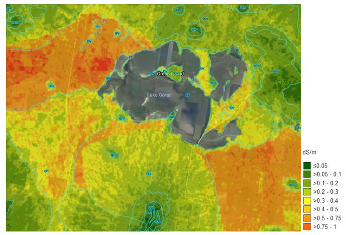
The eSPADE tool also includes predictions of electrical conductivity (EC), which is an important indicator for subsoil salinity. This can be used to identify areas where the risk of subsoil salinity reducing PAWC may be higher. In Figure 7 the EC prediction highlights known areas where subsoil salinity can occur west and south east of Lake Goran. It is important to note, however, that these are predicted properties based on modelling of data obtained in soil surveys. It is important that the predictions are verified on the ground, e.g. through soil analysis of soil cores or electromagnetic (EM) mapping. Subsoil salinity can vary dramatically over short distances – the two PAWC characterisations located north of Spring Ridge NSW with contrasting PAWC due to subsoil salinity (Figure 5h and 5i) were only 2 km apart.
Figure 7. Example of predicted soil properties available for the Liverpool Plains through
eSPADE: EC for 30-100 cm layer).
Acknowledgements
The research undertaken as part of this project is made possible by the significant contributions of growers through both trial cooperation and the support of the GRDC, the authors would like to thank them for their continued support. We also gratefully acknowledge the contributions of CSIRO colleagues and many collaborators and farmers to the field PAWC characterisations. In the Liverpool Plains these included Dick Richards and Michael Bange (CSIRO, Narrabri), George Trumann (LLS), Graeme Schwenke (DPI), consultants Pete McKenzie and Jim Hunt, and local growers. The information on PAWC presented in this paper heavily draws on the work over many years by Neal Dalgliesh (CSIRO). Discussions with him and others, including with those involved with soil-landscape mapping in NSW (Neil McKenzie, Rob Banks, Brian Murphy and Neroli Brennan) were invaluable for the development of concepts and ideas presented in this paper.
Resources
APSoil database (includes link to Google Earth file)
SoilMapp (soil maps, soil characterisation, archive and APSoil sites): Apple iPad app available from App store; documentation:
Soil and Landscape Grid of Australia
eSPADE v2.0 (soil-landscape and land systems mapping and reports, reports on soil characterisation sites from various surveys)
SoilWaterApp: Apple iPad app for estimating soil water during fallow and crops
References
Dalgliesh N (2014) Practical processes for better soil water management. GRDC Update paper.
Fritsch S, Wylie P (2015) Managing the yield gap to achieve your yield potential on the western Downs. GRDC Update paper.
Routley R (2010) Water use efficiency – Optimizing farming systems performance and balancing fallow length and sowing decisions. GRDC Update paper.
Verburg K, Cocks B, Manning B, Truman G, Schwenke GD (2017) APSoil plant available water capacity (PAWC) characterisation of select Liverpool Plain soils and their landscape context, CSIRO, Canberra.
Verburg K, Thomas M, Austin J, Glover M, Stockmann U (2018) GRDC Northern Region scoping study: Available soil information to support prediction of PAWC. CSIRO, Australia.
Whish J (2014) Sorghum yield risk vs starting soil moisture. GRDC Update paper.
Contact details
Dr Kirsten Verburg
CSIRO Agriculture and Food
GPO Box 1700, Canberra ACT 2601
Ph: (02) 6246 5954
Email: kirsten.verburg@csiro.au
® Registered trademark

